Cottonwood Canyon (Utah)
- Not to be confused with Little Cottonwood or Big Cottonwood Canyons, nor with Cottonwood Canyon in San Juan County
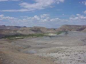
View when entering the canyon on Road 400 from the south after passing over higher elevations from highway 89. The road will follow the watercourse for a while and then (not following the stream) will continue away to the north, following an eroded geologic fault adjacent to the Sawtooth Mountains.
Cottonwood Canyon in the U.S. state of Utah is a water-carved canyon that has eroded along weak locations in the Earth's crust at the joins between major geological regions. To the east are the lower steps of the Grand Staircase, which is not visible from the road and to the north is the Kaiparowits Plateau.[1]
See also
- Road 400 - a dirt road that passes through varied geological features, including a portion of Cottonwood Canyon
Notes
- ↑ Cottonwood Canyon Road, Grand Staircase-Escalante National Monument The American Southwest web site. Retrieved May 22, 2016.
External links
![]()
Coordinates: 37°20′37″N 111°52′14″W / 37.34361°N 111.87056°W
This article is issued from
Wikipedia.
The text is licensed under Creative Commons - Attribution - Sharealike.
Additional terms may apply for the media files.