Cospaia
| Cospaia | |
|---|---|
| Frazione | |
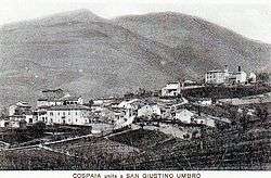 Old view of Cospaia | |
 Cospaia Location of Cospaia in Italy | |
| Coordinates: 43°33′34″N 12°10′15″E / 43.55944°N 12.17083°ECoordinates: 43°33′34″N 12°10′15″E / 43.55944°N 12.17083°E | |
| Country |
|
| Region | Umbria |
| Province | Perugia (PG) |
| Comune | San Giustino |
| Elevation | 357 m (1,171 ft) |
| Time zone | UTC+1 (CET) |
| • Summer (DST) | UTC+2 (CEST) |
| Dialing code | 075 |
Cospaia is an Italian hamlet (frazione) of the comune of San Giustino in the Province of Perugia, Umbria.
History
The village was an autonomous republic from 1440 to 1826, when it was divided between the Grand Duchy of Tuscany and the Papal States.
Geography
Cospaia is located in the northern suburb of San Giustino, by a lake and next to the borders of Umbria with Tuscany. It is 3 km far from Sansepolcro (in the Province of Arezzo), 15 from Città di Castello, 42 from Arezzo and 67 from Perugia.
See also
- Republic of Senarica
- List of historic states of Italy
References
- Ascani, Angelo (1963). Cospaia: storia inedita della singolare Repubblica. Tuscany: Città di Castello.
- Natali, Filippo (1892). La stato libero di Cospaia: nell'alta Valle del Tevere (1440-1826). Umbertide: stab. tip. Tiberino.
External links
![]()
- Thayer's Gazetteer
- La storia ritrovata: La Repubblica di Cospaia (in Italian)
- Cospaia: storia della repubblica più piccola al mondo (in Italian)
- Flag of Cospaia Republic
This article is issued from
Wikipedia.
The text is licensed under Creative Commons - Attribution - Sharealike.
Additional terms may apply for the media files.