Pont de la Concorde (Montreal)
| Concordia Bridge | |
|---|---|
 | |
| Coordinates | 45°30′15″N 73°32′38″W / 45.5042°N 73.5439°WCoordinates: 45°30′15″N 73°32′38″W / 45.5042°N 73.5439°W |
| Carries |
roadway Pedestrians and bicycles |
| Crosses | St. Lawrence River |
| Locale | Montreal, Quebec |
| Characteristics | |
| No. of lanes | 4 |
The Concordia Bridge (Pont de la Concorde) carries Avenue Pierre-Dupuy across the St. Lawrence River between Cité du Havre, Montreal, and Parc Jean-Drapeau on Saint Helen's Island. A majority of its traffic is motorists driving to the Montreal Casino on Île Notre-Dame, continuing on Pierre Dupuy Avenue across Pont des Îles. This bridge was built for Expo 67 and was used by the Montreal Expo Express train.[1]

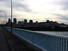
Montreal as seen from the Concorde Bridge
See also
References
- ↑ "Cité du Havre". Grand répertoire du patrimoine bâti de Montréal (in French). City of Montreal. Retrieved 13 November 2011.
External links
Coordinates: 45°30′15″N 73°32′38″W / 45.50417°N 73.54389°W
This article is issued from
Wikipedia.
The text is licensed under Creative Commons - Attribution - Sharealike.
Additional terms may apply for the media files.