Commodore Decatur Airport
| Commodore Decatur Airport Commodore Decatur Army Auxiliary Airfield | |
|---|---|
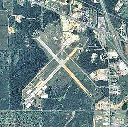 2006 USGS airphoto | |
| Summary | |
| Serves | Bainbridge, Georgia |
| Coordinates | 30°54′56″N 084°36′32″W / 30.91556°N 84.60889°WCoordinates: 30°54′56″N 084°36′32″W / 30.91556°N 84.60889°W |
| Map | |
 Location of Commodore Decatur Airport | |
Commodore Decatur Airport is a closed airport located 2 miles west-northwest of Bainbridge, Georgia.
History
Built by the United States Army Air Forces around 1943, during World War II, the airport was used as an auxiliary training airfield for the Army pilot school at Bainbridge Army Airfield.
With the end of the war, it was turned over to the city of Donalsonville and developed into a municipal airport. It was closed around 1995. Today, the closed airport is used every year for a Bikefest. Motorcycle Clubs from all over the southeast show up for a week & race on the strip & camp out.
The runway on the northwest is complete, with runway markers & lines still visible.
See also
References
![]()
External links
| Wikimedia Commons has media related to Commodore Decatur Airport. |