Colville River (Alaska)
| Colville River | |
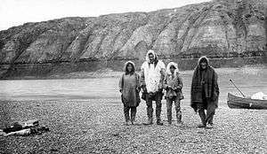 Inupiat family on Colville River, 1901. | |
| Country | United States |
|---|---|
| State | Alaska |
| Borough | North Slope |
| Source | Confluence of Thunder and Storm creeks |
| - location | North slope of the De Long Mountains |
| - elevation | 2,017 ft (615 m) [1] |
| - coordinates | 68°49′01″N 160°21′14″W / 68.81694°N 160.35389°W [2] |
| Mouth | Harrison Bay, Beaufort Sea, Arctic Ocean |
| - location | Northeast of Nuiqsut |
| - elevation | 0 ft (0 m) [2] |
| - coordinates | 70°26′46″N 150°21′28″W / 70.44611°N 150.35778°WCoordinates: 70°26′46″N 150°21′28″W / 70.44611°N 150.35778°W [2] |
| Length | 350 mi (563 km) [2] |
| Basin | 20,500 sq mi (53,000 km2) [3] |
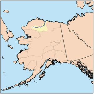 Colville River course and drainage basin in northern Alaska. | |
The Colville River (Inupiat: Kuukpik) is a major river of the Arctic Ocean coast of Alaska in the United States, approximately 350 miles (560 km) long.[2] One of the northernmost major rivers in North America, it drains a remote area of tundra on the north side of the Brooks Range entirely above the Arctic Circle. The river is frozen for more than half the year and floods each spring.
It rises on the north slope of the De Long Mountains, at the western end of the Brooks Range, north of the continental divide in the southwestern corner of the National Petroleum Reserve.[4] It flows initially north, then generally east through the foothills on the north side of the range, broadening as it receives the inflow of many tributaries that descend from the middle Brooks Range.[4] Along its middle course it forms the southeastern border of the National Petroleum Reserve.[4] At the Iñupiat village of Umiat it turns north to flow across the Arctic plain, entering the western Beaufort Sea in a broad delta near Nuiqsut,[4] approximately 120 mi (190 km) west of Prudhoe Bay.
Measuring about 20 by 23 by 26 miles (32 by 37 by 42 km), the river's triangular delta includes 34 distributaries, each with its own mouth, at normal water stages. During high water, the number of distributaries may reach 5,000. The largest distributary is the Nechalic Channel, which flows through Nuiqsut.[3]
The river valley contains developed and undeveloped petroleum and natural gas deposits. In 2015, construction was completed on a bridge spanning the Colville River north of Nuiqsut. This makes it the first major river crossing north of the Arctic Circle in North America. The bridge, at a cost of $100 million, gives its owner ConocoPhillips access to petroleum resources further West in the NPRA.[5]
According to the United States Geological Survey, in 1837 British explorers P. W. Dease and Thomas Simpson named the river for Andrew Colvile, whose last name they spelled "Colville".[2]
Demographics
| Historical population | |||
|---|---|---|---|
| Census | Pop. | %± | |
| 1880 | 50 | — | |
| 1940 | 86 | — | |
| U.S. Decennial Census[6] | |||
Colville River first appeared on the 1880 U.S. Census as an unincorporated area of Inuit (all 50 reported as such).[7] It did not specify where along the river they settled. It did not report again until 1940 when it was erroneously called "Coleville River" on the census. It also did not specify where the residents lived.
Wildlife
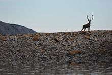
The Colville River and its adjacent hills are home to a variety of Arctic wildlife. The Colville runs through the range of the Teshekpuk and Central Arctic caribou herds, making it a landmark and obstacle in one of the world's largest animal migrations.[8] It is also home to brown bears and, nearer the Arctic coast, polar bears.
The Colville River has been called "hawk heaven" for its incredible concentration of peregrine falcons, gyrefalcons, and golden eagles. The steep, loose bluffs of the Colville River provide prime nesting habitat for many birds.[9][10]
Paleontology
In 1961, Shell Oil geologist Robert Liscolm discovered dinosaur fossils at multiple locations while surveying the Colville River. However, his discoveries were met with incredulity and suspicion in the paleontology community due to the site's extreme northern location, and Liscolm died the following year in a rock slide while continuing his surveying of the Colville. In the mid- to late-1980's, Liscolm's notes were rediscovered and paleontologists returned to Liscolm's sites only to find many more dinosaur fossils and tracks.[11] Today, the Colville River bluffs are widely recognized as one of the fossil-rich regions in the Arctic, with enormous quantities of Cretaceous dinosaur fossils. Specimens collected on the Colville include theropods, ankylosaurs, albertosaurs, pachyrhinosaurus, gorgosaurus, and hadrosaurs.[11][12]
Fossils, which are legally described as any sign or remnant of ancient life, may only be collected from public lands with a government-issued permit.[13] Illegally removing fossils from the Colville River, or other public lands, can expose a violator to steep fines or jail time.
Human activity
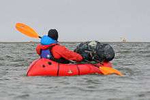
In a region with virtually no roads, the Colville River serves as one of the transportation arteries in the Alaska arctic. In the summer, small motorboats transport indigenous subsistence hunters, paleontologists, geologists, and others working or hunting in the region. When the river freezes to a suitable thickness during winter, it can be used as an ice road to bring in supplies, as seen during the fourth season of the History Channel series Ice Road Truckers. A very small number of recreational boaters float the Colville annually, though the extreme remoteness, harsh conditions, relative lack of air transportation hubs, and presence of polar bears make recreational boating challenging.[14]
See also
References
- ↑ Derived by entering source coordinates in Google Earth.
- 1 2 3 4 5 6 "Colville River". Geographic Names Information System. United States Geological Survey. January 1, 2000. Retrieved September 13, 2013.
- 1 2 Walker, H. Jesse; Hadden, Lynn (1998). "Placing Colville River Delta Research on the Internet in a Digital Library Format" (PDF). University of Alaska Fairbanks. Retrieved September 13, 2013.
- 1 2 3 4 Alaska Atlas & Gazetteer (7th ed.). Yarmouth, Maine: DeLorme. 2010. p. 134–36. ISBN 978-0-89933-289-5.
- ↑ https://www.roadsbridges.com/no-2-colville-river-nigliq-channel-bridge
- ↑ "U.S. Decennial Census". Census.gov. Retrieved June 6, 2013.
- ↑ http://www2.census.gov/prod2/decennial/documents/1880a_v1-17.pdf
- ↑ Alaska Department of Fish and Game, Caribou Species Profile, http://www.adfg.alaska.gov/index.cfm?adfg=caribou.main
- ↑ On Arctic Ground, "Colville River Special Area: Arctic River of Raptors", http://www.onarcticground.org/colville-river/
- ↑ Alaska Department of Fish and Game, "Bird Viewing: Gyrfalcon", http://www.adfg.alaska.gov/index.cfm?adfg=birdviewing.birdersbirds&species=gyrfalcon
- 1 2 Ainsworth, Diane, "Berkeley-led team of teachers digs for Alaskan dinosaur fossils", UC Berkeley Campus News, July 11, 2002, http://www.berkeley.edu/news/media/releases/2002/07/11_fossil.html
- ↑ Schmidt, Chris, "Filming Dinosaurs in Alaska", NOVA, October 7, 2008, https://www.pbs.org/wgbh/nova/evolution/filming-dinosaurs-in-alaska.html
- ↑ "Dinosaurs on Alaska's North Slope," Bureau of Land Management, http://www.blm.gov/pgdata/etc/medialib/blm/ak/aktest/culture_res/culture_pdfs.Par.48740.File.dat/alaska_dinosaurs.pdf
- ↑ "Alaska, Colville River," Backpacker Magazine, June 2003, http://www.backpacker.com/june_2003_destinations_alaska_national_petroleum_reserve/destinations/5925
External links
| Wikimedia Commons has media related to Rivers of Alaska. |