Col d'Ares
| Col d'Ares / Coll d'Ares | |
|---|---|
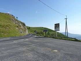 French side of the Col d'Ares | |
| Elevation | 1,513 m (4,964 ft) |
| Location |
Pyrénées-Orientales, France Catalonia, Spain |
| Range | Pyrenees |
| Coordinates | 42°22′2″N 2°27′24″E / 42.36722°N 2.45667°ECoordinates: 42°22′2″N 2°27′24″E / 42.36722°N 2.45667°E |
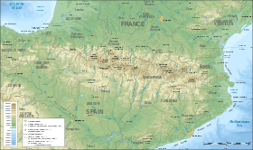 Location in the Pyrenees | |
Col d'Ares (French: [kɔldaʁ]) or Coll d'Ares (Catalan: [ˈkɔʎ ˈdaɾəs]) (el. 1513 m) is a mountain pass in the Pyrenees on the border between France and Spain.
It connects Prats-de-Mollo in France with Molló in Catalonia, Spain.
History
In 1691, during the Nine Years' War, the Spanish passed through the Col d'Ares to try taking Prats-de-Mollo, without success.
See also
References
This article is issued from
Wikipedia.
The text is licensed under Creative Commons - Attribution - Sharealike.
Additional terms may apply for the media files.