Coaley Peak
Coaley Peak is a picnic site and viewpoint in the English county of Gloucestershire.
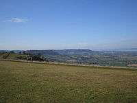
Coaley Peak.
Located about 4 miles (6.4 km) south-west of the town of Stroud overlooking the village of Coaley, Coaley Peak offers 12 acres (4.9 ha) of reclaimed farmland (now a wild flower meadow) with views over the Severn Vale and the Forest of Dean. It is next to a Woodland Trust beech wood and the National Trust's Frocester Hill site. The Cotswold Way long-distance footpath passes through the site. The site includes the excavated Neolithic burial site Nympsfield Long Barrow.
Coaley Peak was for many years a seasonal home to a community of new age travellers, who were evicted around 2002 to make way for more grassland.
External links
- Coaley Peak Homepage
- Map sources for Coaley Peak
This article is issued from
Wikipedia.
The text is licensed under Creative Commons - Attribution - Sharealike.
Additional terms may apply for the media files.