Clavijo
| Clavijo | ||
|---|---|---|
| Municipality | ||
 | ||
| ||
 Clavijo Location in Spain | ||
| Coordinates: 42°21′N 2°25′W / 42.350°N 2.417°W | ||
| Country |
| |
| Autonomous community |
| |
| Province | La Rioja | |
| Comarca | Logroño | |
| Government | ||
| • Mayor | José Fernando Porres Castillo | |
| Area | ||
| • Total | 19.66 km2 (7.59 sq mi) | |
| Elevation | 872 m (2,861 ft) | |
| Population (2009) | ||
| • Total | 276 | |
| • Density | 14/km2 (36/sq mi) | |
| Demonym(s) | Clavillenses | |
| Time zone | UTC+1 (CET) | |
| • Summer (DST) | UTC+2 (CEST) | |
| Postal code | 26130 | |
| Website | Official website | |
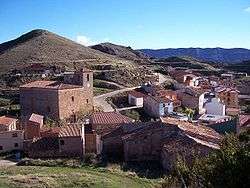
Clavijo is a municipality of the autonomous community of La Rioja (Spain). It is located near the capital, Logroño. As of 2009, its population was of 276 inhabitants.
In 834, according to a 12th-century spurious charter and later traditional records, the legendary battle of Clavijo between Ramiro I of Asturias and Abd ar-Rahman II of Córdoba took place nearby, but the battle was a fabrication and didn't take place.
Main sights
- Castle, built by the Moors in the 9th century
- Monastery of San Prudencio de Monte Laturce, founded in the 6th century
- Hermitage of Santiago (18th century)
- Parish church (16th-17th century)
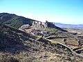 Far view of the Castle of Clavijo
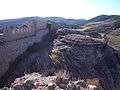 Walls of the Castle
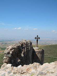 St. James's Cross
| Wikimedia Commons has media related to Clavijo. |
This article is issued from
Wikipedia.
The text is licensed under Creative Commons - Attribution - Sharealike.
Additional terms may apply for the media files.