Clarke River (Westland District)
| Clarke River | |
|---|---|
| Country | New Zealand |
| Physical characteristics | |
| Main source |
Mount Hooker 1,640 m (5,380 ft) |
| River mouth |
Haast River 121 m (397 ft) |
| Length | 27 km (17 mi) |
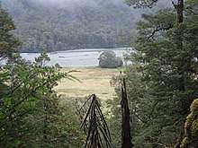
Clarke River from near the Rough Creek Confluence, Westland, Aotearoa, New Zealand.
The Clarke River in Westland District is the southernmost of three rivers thus-named in the South Island of New Zealand. It is a major tributary of the Haast River, flowing southwest from its source on the slopes of Mount Hooker before joining with the Landsborough River three kilometres before the waters of both flow into the Haast at the point where the latter river turns west towards its outflow into the Tasman Sea.
References
- New Zealand 1:50,000 Topographic Map Series, sheet BY13 - Lake Paringa
- New Zealand 1:50,000 Topographic Map Series, sheet BY14 - Mount Ward
Coordinates: 43°55′10″S 169°30′24″E / 43.91944°S 169.50667°E
This article is issued from
Wikipedia.
The text is licensed under Creative Commons - Attribution - Sharealike.
Additional terms may apply for the media files.