Ilhéu de Cima (Porto Santo)
.jpg) Ilhéu de Cima, in the mid-left of the photo seen as small is the islet's lighthouse | |
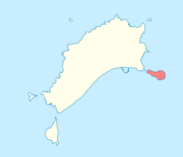
 Location of the islet inside the Municipality of Porto Santo | |
| Geography | |
|---|---|
| Location | Atlantic Ocean |
| Coordinates | 33°3′0″N 16°16′0″W / 33.05000°N 16.26667°WCoordinates: 33°3′0″N 16°16′0″W / 33.05000°N 16.26667°W |
| Total islands | 1 |
| Area | 0.32 km2 (0.12 sq mi) |
| Highest elevation | 111 m (364 ft) |
| Concelhos (Municipalities) | Porto Santo |
| Demographics | |
| Population | 0 |
Ilhéu de Cima are one of six islets located 380 meters from the shore of the island of Porto Santo in northeastern Madeira Islands and is also being uninhabited. The distance with that island is the closest of the six islets. The islet is rocky and its area is 32 hectares which is second in size of the island's surrounding islets and the highest point is 111 meters, half of the islet has coastal cliffs, the middle is like a plateau. The islet also has the easternmost point in the Madeira Islands. Along with all of the islets in the area, it forms a part of Madeira Natural Park. Also the islet is rich in coastal flora.
Due west of the islet in the island is the town centre of Porto Santo.
About the islet
A few kiliometers southeast has waters deeper than 100 metres and further down more than 1,000 metres.
During the Ice Age around 10,000 years ago, along with all of the surrounding islets, it was part of Porto Santo Island. It separated between 5000 to 3000 BC when the sea level was risen nearly to its current level.
Some knowledge of Atlantic islands, such as Madeira, existed before the discovery and settlement of these lands in 1418. The islet was never understood until its recorded discovery when Porto Santo along with the islet were accidentally discovered after captains were storm blown into its sheltered harbor. They were in the service of Infante Henrique of Portugal. João Gonçalves Zarco and Tristão Vaz Teixeira had been ordered by King John I to discover new territory west of Africa and had been sent off-course by a storm while making the volta do mar westward swing return voyage. The islet has never been inhabited.
It is locally known as Ilhéu do Farol as the island also has its own (Farol do Ilhéu de Cima) lighthouse located in the eastern end first built in 1900.[1] The lighthouse is very important as it is the first lighthouse used for vessels heading from Europe.[2] The lighthouse height is 15 m and the focal height is at 124 m. Another Ilhéu do Farol is located wet-southwest and is east of the Madeira Island.
Nature
The island's flora consists of grass and flowers. The island's fauna consists of only birds and molluscs, one land snail species founded is the endemic Lampadia webbiana, another is Amphorella cimensis. Surrounding the islet in the Atlantic are marine fauna including fishes, sharks and molluscs (ex. sea snails and sea slugs).
References
- ↑ Municipal Bulletin of Porto Santo (in Portuguese). Municipality of Porto Santo. p. 32.
- ↑ Farol do Ilhéu de Cima. EMAM (Estrutura de Missão para os Assuntos do Mar). Retrieved 7 May 2009.
External links
- Photo of Ilhéu de Cima (in Portuguese)