Chong-Kemin River
| Chong-Kemin River (Чоң-Кемин дарыясы) | |
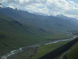 Chong-Kemin River. View from Ozernyi Pass. | |
| Country | Kyrgyzstan |
|---|---|
| Region | Chuy Province |
| District | Kemin District |
| Mouth | Chu River |
| - location | Boom Gorge, Kemin District, Chuy Province, Kyrgyzstan |
| - coordinates | 42°41′28.3″N 75°53′27.9″E / 42.691194°N 75.891083°ECoordinates: 42°41′28.3″N 75°53′27.9″E / 42.691194°N 75.891083°E |
| Length | 116 km (72 mi) |
| Basin | 1,890 km2 (730 sq mi) |
| Discharge | mouth |
| - average | 21.7 m3/s (766 cu ft/s) |
| - max | 83.7 m3/s (2,956 cu ft/s) |
| - min | 7.18 m3/s (254 cu ft/s) |
The Chong-Kemin River (Kyrgyz: Чоң-Кемин дарыясы, Çoñ-Kemin darıyası) is a river in Kemin District of Chuy Province of Kyrgyzstan. It is a right tributary of the Chu River in Boom Gorge.
It has a length of 116 kilometres (72 mi) with a basin area of 1,890 square kilometres (730 sq mi).
Bibliography
- Chuy Oblast Encyclopedia. Kyrgyz Encyclopedia Chief Editorial Board. Bishkek, 1994 (in Kyrgyz and Russian). ISBN 5-89750-083-5
This article is issued from
Wikipedia.
The text is licensed under Creative Commons - Attribution - Sharealike.
Additional terms may apply for the media files.