Chino Canyon (California)
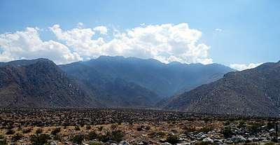
Chino Canyon is a 5.5-mile-long (8.9 km) desert canyon, and its associated stream is a tributary of the Whitewater River in Riverside County, California, United States. The canyon is located in the northern part of the San Jacinto Mountains and is part of the Coachella Valley. It is one of the steepest canyons in North America, dropping from over 8,500 feet (2,600 m) at the south rim to less than 2,700 feet (820 m) on the valley floor in less than a mile. The southernmost, upper reaches of the canyon are bordered by Mount San Jacinto State Park. The canyon mouth at the north end is being encroached by the outskirts of Palm Springs, California. Chino Canyon is the site of the Palm Springs Aerial Tramway.[1]
Chino Canyon Creek
Chino Canyon is a desert canyon fed by springs. These produce a waterfall and a stream that peaks out at about 5.4 ft3 per second (0.15 m3 per second). The stream flows under the Aerial Tramway Valley Station and later dries up about 3.5 miles down the canyon.[2]
Coordinates: 33°51′52″N 116°34′16″W / 33.86444°N 116.57111°W[3]
Notes
- ↑ http://www.desertusa.com/magnov97/tram/nov_tram.html
- ↑ "Archived copy". Archived from the original on 2008-09-16. Retrieved 2008-08-24.
- ↑ U.S. Geological Survey Geographic Names Information System: Chino Canyon