Chaseley, North Dakota
| Chaseley | |
|---|---|
| Unincorporated community | |
 Church in Chaseley | |
 Chaseley Location within the state of North Dakota  Chaseley Chaseley (the US) | |
| Coordinates: 47°27′1″N 99°49′12″W / 47.45028°N 99.82000°WCoordinates: 47°27′1″N 99°49′12″W / 47.45028°N 99.82000°W | |
| Country | United States |
| State | North Dakota |
| County | Wells |
| Elevation | 1,867 ft (569 m) |
| Time zone | UTC-6 (Central (CST)) |
| • Summer (DST) | UTC-5 (CDT) |
| ZIP codes | 58423 |
| Area code(s) | 701 |
| GNIS feature ID | 1028349 |
Chaseley is an unincorporated community in southwestern Wells County, North Dakota, United States. It lies along North Dakota Highway 200 southwest of the city of Fessenden, the county seat of Wells County.[1] Its elevation is 1,867 feet (569 m).[2] It formerly had a post office, with the ZIP code of 58423.[3]
References
- ↑ Rand McNally. The Road Atlas '08. Chicago: Rand McNally, 2008, p. 77.
- ↑ U.S. Geological Survey Geographic Names Information System: Chaseley, North Dakota, Geographic Names Information System, 1980-02-13. Accessed 2008-03-28.
- ↑ Zip Code Lookup Archived May 17, 2011, at the Wayback Machine.
Municipalities and communities of Wells County, North Dakota, United States | ||
|---|---|---|
| Cities | 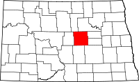 | |
| Townships |
| |
| CDP | ||
| Unincorporated communities | ||
This article is issued from
Wikipedia.
The text is licensed under Creative Commons - Attribution - Sharealike.
Additional terms may apply for the media files.