Charkop
Coordinates: 19°12′58″N 72°49′50″E / 19.216182°N 72.830575°E
Charkop is a locality in the suburb of Kandivali (West), North Mumbai. It was originally intended as a housing project by MHADA, around the existing village with the same name but now covers residential areas and businesses.
History
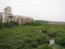
Charkop's original name is 'Char Khop'( चार खोप ) meaning a place of 4 huts or a small village with four houses in Marathi. Koli people or the fishermen are considered to be the indigenous residents of Charkop. Charkop was originally a marshy land surrounded by mangroves, drained by the MHADA to provide low-cost housing to people. The project was originally intended to provide society-based plots around 250 square feet (23 m2) to every owner. This ownership was established by having a lottery and allotting lottery numbers. The next step was to provide all necessary civil amenities, which MHADA has provided to full effect. After the year 2000, Charkop had gradually established itself in the metropolitan fold of Mumbai due to its close proximity to both Kandivali and Borivali suburbs. Charkop has been divided into 9 sectors.
Transport
The area is well connected to the Kandivali, Borivali and Malad suburbs by a number of BEST buses and private transport. Nearest local railway station is Kandivali railway station. Nearest railway station for long distance trains is Borivali railway station. Ferry ride to the opposite side of Gorai Creek is available from nearby Gorai. Most frequently used BEST transport routes are:
- Route 276 and 239: Kandivlai Station (W) to Charkop Sector no. 8/9
- Route 244, 246 and 277: Borivali station to Kandivali station via Charkop.
- Route 245: P Thakre Nagar Bus Station Charkop to P Thakre Nagar Bus Station - Mumbai Via Borivali station Ring route
- Route 269: Borivali to Madh beach via Charkop
- Route 294: Gorai Bus Depot to Andheri Station (W) via Charkop
- Route 460 LTD, 461 LTD, 226 LTD: Charkop to Eastern Suburbs via Jogeshwari–Vikhroli Link Road.
Demographics
The original inhabitants of Charkop, the Koli people are Hindus. The present demographic of Charkop is a reflection of the cosmopolitan makeup of Mumbai. The region is predominantly Hindu, but there are also tiny pockets of Christians, Sikhs, Jains, Buddhists, Parsis and Muslims. Most residents belong to the lower middle-class or middle class. The majority of populace is Marathi-speaking although a tiny amount of other people speak their respective languages.
Proposed developments
Metro connecting Charkop to Mankhurd is next to follow, after Mumbai Metro One is complete. However, with the operator MMTPL and MMRDA sparring on right of way, the proposed Charkop-Mankhurd metro faces a stillborn fate. There is also a popular citizen's movement in favour of an underground metro and same views have been echoed by the current Chief Minister of Maharashtra, Prithviraj Chauhan, after inspecting the condition of Mumbai Metro One, whose overground bridges kiss residential buildings and commercial establishments.
MCGM has planned to create a bird sanctuary to preserve and exhibit the various types of birds that frequent the mangrove areas of Sector 8. However,there are no updates on this project, after this was announced in 2007-08.
Schools
- Kapol Vidyanidhi International School (ICSE), Sector 3
- Indian Education Society High School Sector-2
- St.Mary's High School Sector-2
- K B Patil International School at Charkop Sector 8
- Ekvira High School Sector-1.
- Mother Teresa High School Sector-1.
- Oxford Public School Sector-5.
- Akshara High School, Sector-8
- sanskar school,sector-5
See also
References
This area is developed