Chapman's Peak
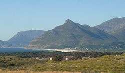
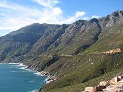
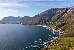
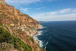
Chapman's Peak is the name of a mountain on the western side of the Cape Peninsula, between Hout Bay and Noordhoek in Cape Town, South Africa. The western flank of the mountain falls sharply for hundreds of metres into the Atlantic Ocean, and a spectacular road, known as Chapman's Peak Drive, hugs the near-vertical face of the mountain, linking Hout Bay to Noordhoek.
Chapman's Peak Drive is part of the route of two of South Africa's biggest mass-participation races, the Cape Argus Cycle Race and the Two Oceans Marathon.
History
Chapman's Peak is named after John Chapman, the pilot of an English ship becalmed in today's Hout Bay in 1607. The skipper sent his pilot ashore to find provisions, and the name was recorded as Chapman's Chaunce.[1]
Chapman's Peak Drive was hacked out of the face of the mountain between 1915 and 1922, and at the time was regarded as a major feat of engineering. In 1991, the road was featured in an advertisement for Mercedes Benz, in which a 1988 car crash was recreated, to illustrate the safety of Mercedes Benz cars.[2] The road was closed in the 1990s, after a rockfall caused a death and a subsequent lawsuit,[3] and subsequently reopened after being re-engineered to protect motorists from falling rocks. It was reopened in 2005 as a toll road. The road was again closed for a number of months beginning on 19 June 2008 "as a result of risk areas identified on the mountain above the road".[4]
Geology
The top of Chapman's Peak consists of flat, sedimentary rocks related to those that form Table Mountain. The base of the mountain, however, consists of Cape Granite and the two formations meet at a geological unconformity that is world-famous amongst earth scientists.
Two different endangered vegetation types can be found along this road, and correspond to the two main geological formations. They are Peninsula Sandstone Fynbos and Cape Granite Fynbos and they are both endemic to the city of Cape Town, occurring nowhere else.[5][6]
There is an old, abandoned manganese mine on the northwestern slopes of the peak. The remains of a jetty from which the ore used to be shipped are directly below the workings.
Gallery
.jpg) Sunset at Hout Bay viewed from Chapman's Peak Drive
Sunset at Hout Bay viewed from Chapman's Peak Drive.jpg) Before sunset at Hout Bay viewed from Chapman's Peak Drive
Before sunset at Hout Bay viewed from Chapman's Peak Drive.jpg) Chapman's Peak Drive sign
Chapman's Peak Drive sign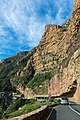 Rockfall shelters on Chapman's Peak Drive
References
- ↑ "History of Chapman's Peak Drive". chapmanspeakdrive.co.za. Retrieved 4 June 2016.
- ↑ https://www.youtube.com/watch?v=BcHocs4CA8A
- ↑ "The BTA Chapman's Peak Fund". Retrieved 28 July 2017.
- ↑ Chapman's Peak Drive
- ↑ "Cape Granite Fynbos. Cape Town Biodiversity Factsheets" (PDF). Retrieved 3 August 2017.
- ↑ "Peninsula Sandstone Fynbos. Cape Town Biodiversity Factsheets" (PDF). Retrieved 3 August 2017.
External links
| Wikimedia Commons has media related to Chapman's Peak. |