Txamantxoia
| Txamantxoia | |
|---|---|
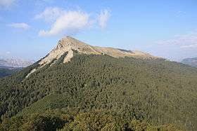 View of Peña del Rey in Txamantxoia | |
| Highest point | |
| Elevation | 1,945 m (6,381 ft) |
| Coordinates | 42°54′12″N 00°48′56″W / 42.90333°N 0.81556°WCoordinates: 42°54′12″N 00°48′56″W / 42.90333°N 0.81556°W |
| Geography | |
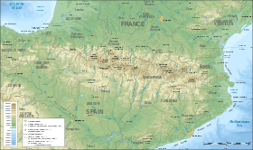 Txamantxoia Location in the Pyrenees | |
| Location |
Jacetania (Aragon) Belagua (Navarre) |
| Parent range | Pyrenees |
| Climbing | |
| First ascent | Unknown |
| Easiest route | From Isaba |
Txamantxoia or Maze (Spanish: Chamanchoya) (1,945 m) is a mountain in the Pyrenees. It is located between the Ansó Valley in Aragon and the Belagua Valley in Navarre, Spain.
External links
| Wikimedia Commons has media related to Txamantxoia. |
- Mendikat - Txamantxoia (in Spanish)
This article is issued from
Wikipedia.
The text is licensed under Creative Commons - Attribution - Sharealike.
Additional terms may apply for the media files.