Hundred of Chafford
| Chafford Hundred | |
|---|---|
 | |
| Area | |
| • 1870 | 35,712 acres (144.52 km2) |
| • 1887 | 34,703 acres (140.44 km2) |
| Population | |
| • 1870 | 16,001[1] |
| • 1887 | 23,839[2] |
| History | |
| • Created | Anglo-Saxon |
| • Abolished | no administrative or legal role after 1886, but never formally abolished. |
| • Succeeded by | various, see text |
| Status | hundred |
| • HQ | Chafford Heath |
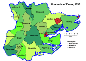
Chafford was an ancient hundred in the south west of the county of Essex, England.[3] Its area has been partly absorbed by the growth of London; with its name reused for the modern housing development of Chafford Hundred. Its former area now corresponds to part of the London Borough of Havering in Greater London and parts of the districts of Brentwood and Thurrock in Essex.
History
Hundred meetings are thought to have taken place in Chafford Heath[4] (grid reference TQ564836) in the southern part of the ecclesiastical parish of Upminster.
The hundred contained the parishes of Aveley, Brentwood, Childerditch, Cranham, Grays Thurrock, Great Warley, Little Warley, North Ockendon, Rainham, South Ockendon, South Weald, Stifford, Upminster, Wennington and West Thurrock.[5]
It bordered Ongar hundred to the north, Barstable hundred to the east and Havering liberty to the west. The River Thames formed a 7-mile (11 km) boundary with Kent to the south.[5] The hundred covered a narrow area stretching 12 miles (19 km) northwards from the river.[1]
Replacement
The hundreds of England declined in administrative use because of the rise of various ad-hoc boards. By 1894 they were effectively replaced by a system of uniform local government districts, which were consolidated over time and finally replaced by the London boroughs (1965) and non-metropolitan districts (1974), further change occurred in 1998 when Thurrock became a unitary authority.
| Parish | District | Today |
|---|---|---|
| Aveley | Orsett Rural District | Thurrock |
| Brentwood | Billericay Rural District | Brentwood |
| Childerditch | Billericay Rural District | Brentwood |
| Cranham | Romford Rural District | Havering |
| Grays Thurrock | Grays Thurrock Urban District | Thurrock |
| Great Warley | Romford Rural District | Brentwood |
| Little Warley | Billericay Rural District | Brentwood |
| North Ockendon | Romford Rural District | Havering |
| Rainham | Romford Rural District | Havering |
| South Ockendon | Orsett Rural District | Thurrock |
| South Weald | Billericay Rural District | Brentwood |
| Stifford | Orsett Rural District | Thurrock |
| Upminster | Romford Rural District | Havering |
| Wennington | Romford Rural District | Havering |
| West Thurrock | Orsett Rural District | Thurrock |
See also
References
- 1 2 IGEW John Marius Wilson: Imperial Gazetteer of England and Wales (1870-72)
- ↑ John Bartholomew, Gazetteer of the British Isles, (1887)
- ↑ Vision of Britain - Chafford hundred Archived 2007-09-30 at the Wayback Machine. (historic map Archived 2007-10-01 at the Wayback Machine.)
- ↑ History of the County of Essex: Volume 7, Chafford hundred: Introduction, (1978)
- 1 2 British History Online - Map of Chafford Hundred c. 1845