Château-Thierry – Belleau Aerodrome
| Château-Thierry - Belleau Aerodrome Aérodrome de Château-Thierry - Belleau | |||||||||||
|---|---|---|---|---|---|---|---|---|---|---|---|
 | |||||||||||
| Summary | |||||||||||
| Airport type | Public | ||||||||||
| Operator | Club aéronautique de Château Thierry | ||||||||||
| Serves | Château-Thierry, France | ||||||||||
| Location | Belleau | ||||||||||
| Elevation AMSL | 723 ft / 220 m | ||||||||||
| Coordinates | 49°04′00″N 003°21′20″E / 49.06667°N 3.35556°ECoordinates: 49°04′00″N 003°21′20″E / 49.06667°N 3.35556°E | ||||||||||
| Map | |||||||||||
 LFFH Location of airport in Aisne department Location of Aisne department in France 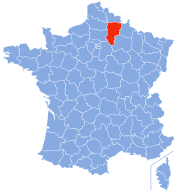 | |||||||||||
| Runways | |||||||||||
| |||||||||||
Château-Thierry - Belleau Aerodrome (French: Aérodrome de Château-Thierry - Belleau) (ICAO: LFFH) is an aerodrome or airport located 3 km (2 NM) northwest of Château-Thierry[1] and southeast of Belleau, both communes in the Aisne department of the Picardy (Picardie) region in France.
Facilities
The airport resides at an elevation of 723 feet (220 m) above mean sea level. It has one runway designated 04/22 with a grass surface measuring 930 by 50 metres (3,051 ft × 164 ft).[1]
The airport is not controlled. The communications frequency is 120.375 MHz, which is shared with the nearby Soissons-Courmelles Aerodrome.
References
- 1 2 3 LFFH – CHÂTEAU-THIERRY BELLEAU. AIP from French Service d'information aéronautique, effective 11 October 2018.
External links
- (in French) Aéroclub de CHATEAU THIERRY
- Airport information for LFFH at Great Circle Mapper.
- Accident history for LFFH at Aviation Safety Network
This article is issued from
Wikipedia.
The text is licensed under Creative Commons - Attribution - Sharealike.
Additional terms may apply for the media files.