Central American montane forests
| Central American montane forests | |
|---|---|
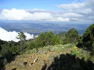 Central American Montane forests, with Pinus hartwegii, on the slopes of Tajumulco volcano, Guatemala. | |
| Ecology | |
| Biome | Tropical and subtropical moist broadleaf forests |
| Geography | |
| Area | 13,200 km2 (5,100 sq mi) |
| Countries | Mexico (Chiapas), Guatemala, El Salvador, Honduras and Nicaragua |
| Conservation | |
| Conservation status | Vulnerable[1] |
| Global 200 | Yes |
The Central American montane forests are an ecoregion of the tropical and subtropical moist broadleaf forests biome, as defined by the World Wildlife Fund, located in mountains of Central America. [1]
Description
Central American montane forests consist of forest patches located at altitudes ranging from 1,800–4,000 metres (5,900–13,100 ft), on the summits and slopes of the highest mountains in Central America, including the Sierra Madre de Chiapas. It extends from Chiapas state in southeastern Mexico, through Guatemala, El Salvador, and Honduras, to northern Nicaragua.
The ecoregion covers an area of 13,200 square kilometres (5,100 sq mi)2.[1] The ecoregion has a temperate climate with relatively high precipitation levels.[1]
See also
- Ecoregions of Central America
- List of tropical and subtropical moist broadleaf forests ecoregions
| Wikimedia Commons has media related to Central American montane forests. |
References
- 1 2 3 4 "Central American montane forests". Terrestrial Ecoregions. World Wildlife Fund. Retrieved 2013-08-20.
- World Wildlife Fund, ed. (2001). "Central American montane forests". WildWorld Ecoregion Profile. National Geographic Society. Archived from the original on 2010-03-08.
This article is issued from
Wikipedia.
The text is licensed under Creative Commons - Attribution - Sharealike.
Additional terms may apply for the media files.