List of G:link stations
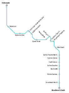
There are nineteen stations in the G:link, a light rail system serving the Gold Coast in Queensland, Australia. The system consists of a single 20-kilometre (12 mi) line that opened with sixteen initial stations on 20 July 2014,[1] with another three stations opening on 17 December 2017.[2] It is operated under contract by Keolis Downer and funded jointly by local, state and federal governments.[1] The system's average daily ridership is 21,000 as of February 2016.[3]
Helensvale is the northern terminus of the system, connecting with Helensvale railway station, while Broadbeach South is the southern terminus. One station is located in Helensvale, two are located in Parkwood, seven stations are located in Southport, one is in Main Beach, six are in Surfers Paradise, and two are in Broadbeach. TransLink charges fares that increase as passengers travel through eight concentric zones radiating outward from the Brisbane central business district;[4] all of the stations are located within zone 5. Eighteen of the stations are street-level open-air structures featuring passenger canopies, and one is underground. Eleven stations have side platforms and eight have an island platform. It takes 45 minutes to travel from one end of the line to the other. Between Gold Coast University Hospital and Broadbeach South, eight of the stations have kiosks, six stations offer transfers to TransLink bus services and none have park and ride lots.[5] The most heavily trafficked station is Cavill Avenue, with an average 4,729 daily passengers in February 2016.[3]
Following public consultation, a 20.5-kilometre (12.7 mi) southern extension that will terminate at the Gold Coast Airport is in the planning stages.[6]
Stations
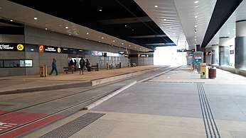 Gold Coast University Hospital, the original northern terminus and the only underground station in the system.
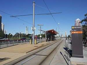 Main Beach is a simple island platform.
.jpg) Broadbeach South, the southern terminus, features cross-platform interchange between trams and buses.
Broadbeach South, the southern terminus, features cross-platform interchange between trams and buses.
| Transfer station to TransLink bus services | |
| Transfer station to TransLink bus services and to the Gold Coast railway line | |
Park and ride facilities are available at Helensvale and Parkwood stations. During the construction of Stage 2, 1000 car park spaces were built at the new Parkwood station, while 400 new car park spaces were built at Helensvale, in addition to the 877 existing spaces at the adjacent Helensvale railway station.[28]
See also
Notes
- ↑ The travel time in minutes from Helensvale, the northern terminus of the system.
References
- 1 2 Moore, Tony (20 July 2014). "All aboard – GC light rail takes off". Brisbane Times. Fairfax Media. Archived from the original on 10 May 2017. Retrieved 10 June 2016.
- ↑ "Gold Coast Light Rail extension opens". RACQ. 17 December 2017. Archived from the original on 24 May 2018. Retrieved 17 December 2017.
- 1 2 Skene, Kathleen (14 May 2016). "Gold Coast light rail hits 10 million tram passenger mark as tender announcement nears for stage two". The Gold Coast Bulletin. News Corp Australia. Archived from the original on 13 February 2017. Retrieved 10 June 2016.
- ↑ "Zones". TransLink. Queensland Government. 2016. Archived from the original on 1 June 2016. Retrieved 11 June 2016.
- ↑ Elder, Jessica (18 January 2014). "Gold Coast Light rail passengers will have no where to park and ride". The Gold Coast Bulletin. News Corp Australia. Retrieved 10 June 2016.
- ↑ Potts, Andrew (12 May 2016). "Gold Coast Council community consultation backs southern coastal light rail airport link". The Gold Coast Bulletin. News Corp Australia. Archived from the original on 18 June 2016. Retrieved 15 June 2016.
- ↑ "G:link". TransLink. Queensland Government. 2016. Archived from the original on 3 April 2016. Retrieved 17 December 2017.
- ↑ Wuth, Robyn (16 August 2015). "Gold Coast light rail kiosks a 'slap in the face' to nearby traders". The Gold Coast Sun. News Corp Australia. Retrieved 10 June 2016.
- ↑ "Helensvale". RideTheG. Keolis Downer. 2017. Archived from the original on 12 March 2018. Retrieved 17 December 2017.
- ↑ "Parkwood". RideTheG. Keolis Downer. 2017. Archived from the original on 12 March 2018. Retrieved 17 December 2017.
- ↑ "Parkwood East". RideTheG. Keolis Downer. 2017. Archived from the original on 12 March 2018. Retrieved 17 December 2017.
- ↑ "Gold Coast University Hospital". RideTheG. Keolis Downer. 2016. Archived from the original on 8 August 2016. Retrieved 17 August 2016.
- ↑ "Griffith University". RideTheG. Keolis Downer. 2016. Archived from the original on 9 August 2016. Retrieved 17 August 2016.
- ↑ "Queen Street". RideTheG. Keolis Downer. 2016. Archived from the original on 9 August 2016. Retrieved 17 August 2016.
- ↑ "Nerang Street". RideTheG. Keolis Downer. 2016. Archived from the original on 9 August 2016. Retrieved 17 August 2016.
- ↑ "Southport". RideTheG. Keolis Downer. 2016. Archived from the original on 8 August 2016. Retrieved 17 August 2016.
- ↑ "Southport South". RideTheG. Keolis Downer. 2016. Archived from the original on 9 August 2016. Retrieved 17 August 2016.
- ↑ "Broadwater Parklands". RideTheG. Keolis Downer. 2016. Archived from the original on 9 August 2016. Retrieved 17 August 2016.
- ↑ "Main Beach". RideTheG. Keolis Downer. 2016. Archived from the original on 9 August 2016. Retrieved 17 August 2016.
- ↑ "Surfers Paradise North". RideTheG. Keolis Downer. 2016. Archived from the original on 9 August 2016. Retrieved 17 August 2016.
- ↑ "Cypress Avenue". RideTheG. Keolis Downer. 2016. Archived from the original on 9 August 2016. Retrieved 17 August 2016.
- ↑ "Cavill Avenue". RideTheG. Keolis Downer. 2016. Archived from the original on 9 August 2016. Retrieved 17 August 2016.
- ↑ "Surfers Paradise". RideTheG. Keolis Downer. 2016. Archived from the original on 8 August 2016. Retrieved 17 August 2016.
- ↑ "Northcliffe". RideTheG. Keolis Downer. 2016. Archived from the original on 8 August 2016. Retrieved 17 August 2016.
- ↑ "Florida Gardens". RideTheG. Keolis Downer. 2016. Archived from the original on 9 August 2016. Retrieved 17 August 2016.
- ↑ "Broadbeach North". RideTheG. Keolis Downer. 2016. Archived from the original on 8 August 2016. Retrieved 17 August 2016.
- ↑ "Broadbeach South". RideTheG. Keolis Downer. 2016. Archived from the original on 14 August 2016. Retrieved 17 August 2016.
- ↑ "Helensvale – Zone 12". Queensland Rail. 2016. Archived from the original on 16 March 2016. Retrieved 10 June 2016.
External links
