Microregion of Catalão
| Catalão | |
|---|---|
| Microregion | |
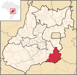 Location in Goias state | |
| Country | Brazil |
| State | Goiás |
| Mesoregion | Sul Goiano |
| Municipalities | 11 |
| Area | |
| • Total | 15,239 km2 (5,884 sq mi) |
| Population (2006) | |
| • Total | 131,741 |
| • Density | 8.6/km2 (22/sq mi) |
The Catalão Microregion is a statistical microregion created by IBGE (Instituto Brasileiro de Geografia e Estatística) in south-eastern Goiás state, Brazil. A region of rolling hills and flatlands with extensive cattle raising and soybean plantations. The regional center, Catalão, is growing fast with important industries being installed in the area. The GDP of this region represented almost 5% of the state GDP in 2003.
Municipalities
The microregion consists of the following municipalities:[1]
| Municipality | Area (km²) | Inhabitants in 2007, July | GDP (R$ 1.000,00) in 2003 | |
|---|---|---|---|---|
| Anhanguera | 57 | 914 | 4,282 | |
| Campo Alegre de Goiás | 2,463 | 4,522 | 108,251 | |
| Catalão | 3,778 | 71,680 | 1,900,010 | |
| Corumbaíba | 1,482 | 7,487 | 129,590 | |
| Cumari | 580 | 3,269 | 21,251 | |
| Davinópolis | 520 | 2,029 | 13,393 | |
| Goiandira | 561 | 4,671 | 25,555 | |
| Ipameri | 4,369 | 23,984 | 304,634 | |
| Nova Aurora | 303 | 1,988 | 11,845 | |
| Ouvidor | 414 | 4,691 | 84,420 | |
| Três Ranchos | 282 | 3,253 | 12,633 | |
| Municipalities of Catalão Microregion, in Goiás, BrasilIBGE. | ||||
Population figures are from 2007.
See also
References
- ↑ Instituto Brasileiro de Geografia e Estatística, territorial division.
Coordinates: 18°10′12″S 47°56′31″W / 18.17000°S 47.94194°W
This article is issued from
Wikipedia.
The text is licensed under Creative Commons - Attribution - Sharealike.
Additional terms may apply for the media files.