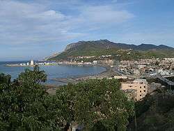
Ténès
| Ténès | |
|---|---|
 | |
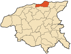 within the Chlef wilaya | |
| Coordinates: 36°30′44″N 1°18′16″E / 36.51222°N 1.30444°ECoordinates: 36°30′44″N 1°18′16″E / 36.51222°N 1.30444°E | |
| Area | |
| • Total | 101 km2 (39 sq mi) |
| Elevation | 779 m (2,556 ft) |
| Population (2008) | |
| • Total | 35,459 |
| • Density | 350/km2 (910/sq mi) |
|
| |
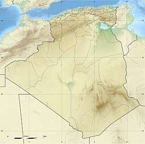 Algeria | |
| Location |
Cap Ténès Ténès Algeria |
|---|---|
| Coordinates | 36°32′58.87″N 1°20′26.12″E / 36.5496861°N 1.3405889°E |
| Year first constructed | 1861[1] |
| Foundation | stone base |
| Construction | stone tower |
| Tower shape | quadrangular tower with balcony and lantern |
| Markings / pattern | white lantern, dark green lantern |
| Height | 31.50 metres (103.3 ft)[1] |
| Focal height | 94.50 metres (310.0 ft)[1] |
| Light source | mains power |
| Intensity | 1,000 W |
| Range | 29 nautical miles (54 km; 33 mi)[1] |
| Characteristic | Fl (2) W 10s.[2] |
| Admiralty number | E6646 |
| NGA number | 22488 |
| ARLHS number | ALG-018[3] |
| Managing agent | Office Nationale de Signalisation Maritime |
Ténès (Berber languages: Tinas; Arabic: تنس) is a town in Algeria located around 200 kilometers west of the capital Algiers. As of 2000, it has a population of 35,000 people.
History
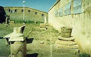
Ténès is an ancient Berber-Punic-Roman town which has existed since the 8th century BC. The city was founded on the site of an old Phoenician colony. During the Roman period, it was known as Cartenna. According to Ptolemy, the area was inhabited by the Bakoyta, a native Berber group.[4] The Romans occupied the city for around five centuries.
Later the town was conquered by the Umayyad Caliphate for a short period. Under Islamic Umayyad rule, Ténès was an independent monarchy. The Sultan Hamid El Abd was the last ruler of the monarchy of Ténès. After the Berbers removed the Umayyad occupation during the Great Berber Revolt, the Kharijite Islamic denomination spread in the city and later Shia Islam dominated during the Fatimids rule. The city was conquered by the Sunni Muslim Berber empire of the Almohad Caliphate coming from present-day Morocco.
The Ottoman Empire attacked Ténès, defeated its army and annexed it to their vast empire in 1512. From that time Ténès lost its fame and importance and became an isolated town. Ténès Al-Atiqa (old-Ténès or the lighthouse of Sufism) was built by the Moors who escaped from Spanish persecution in the 15th century after the collapse of the Moorish states in Spain.
In 1843, Ténès was occupied by the French, who declared it a township and rebuilt the ancient Cartenna some two kilometers to the north of Ténès-al-Atiqa.
Present
At the present time Ténès is a small tourist town with five small hotels, two hospitals, a local museum, a port and a lighthouse. It has some antique sites such as the Phoenician and Roman tombs, the prehistoric caves in Sidi Merouane, the Great Mosque of Sidi Ahmed Boumaza[5] (built some 11 centuries ago), Bab El Bahr, Notre Dame de Ténès, The French cannons, along with many others.
See also
- List of lighthouses in Algeria
- Diocesi di Cartenna on Italian Wikipedia
- Cartennas
References
- 1 2 3 4 "Cap Tenes". Office Nationale de Signalisation Maritime. Ministere des Travaux Publics. Retrieved 28 April 2017.
- ↑ List of Lights, Pub. 113: The West Coasts of Europe and Africa, the Mediterranean Sea, Black Sea and Azovskoye More (Sea of Azov) (PDF). List of Lights. United States National Geospatial-Intelligence Agency. 2015.
- ↑ "Western Algeria". The Lighthouse Directory. University of North Carolina at Chapel Hill. Retrieved 28 April 2017.
- ↑ Playfair, Robert Lambert (1891). Handbook for Travellers in Algeria and Tunis. J. Murray. pp. 246–247. Retrieved 18 March 2018.
- ↑