Cape Kolka
| Cape Kolka | |
|---|---|
| Livonian: Kūolka nanā, Latvian: Kolkasrags | |
 Cape Kolka. | |
 | |
| Coordinates | 57°45′32.2″N 22°36′17.1″E / 57.758944°N 22.604750°ECoordinates: 57°45′32.2″N 22°36′17.1″E / 57.758944°N 22.604750°E |
| Offshore water bodies | Irbe Strait, Gulf of Riga, Baltic Sea |
| Elevation | 2 metres (6 ft 7 in) |
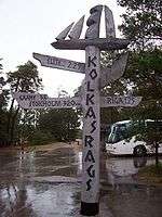
Kolka Signpost
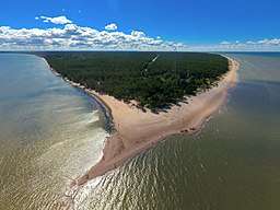
Cape Kolka (Livonian: Kūolka nanā, Latvian: Kolkasrags, Old German name - Domesnes, Russian - Колка or мыс Домеснес) - cape on the Baltic Sea, near the entry to Gulf of Riga, in Livonian coast, in the Courland Peninsula of Latvia. The cape is surrounded by the Irbe Strait (Irbes šaurums) which serves as the natural border with Estonia. Cape Kolka represents the north-western limit of the Gulf of Riga. East of the cape is the island of Ruhnu (Estonia) that lies in the middle of the Gulf.
Near the cape is Kolka lighthouse and the village of Kolka. There is a line of picturesque old Livonian settlements along the Baltic Sea shore, including Vaide, Saunags, Pitrags, Košrags and Sīkrags.
See also
External links
This article is issued from
Wikipedia.
The text is licensed under Creative Commons - Attribution - Sharealike.
Additional terms may apply for the media files.