Cape Agulhas
Cape Agulhas (/əˈɡʌləs/; Portuguese: Cabo das Agulhas [ˈkaβu ðɐz ɐˈɣuʎɐʃ], "Cape of the Needles") is a rocky headland in Western Cape, South Africa.
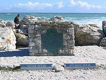
It is the geographic southern tip of the African continent and the beginning of the dividing line between the Atlantic and Indian Oceans according to the International Hydrographic Organization.[1]
Historically, the cape has been known to sailors as a major hazard on the traditional clipper route. It is sometimes regarded as one of the great capes. It was most commonly known in English as Cape L'Agulhas until the 20th century. The town of L'Agulhas is located near to the cape.
Geography
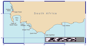
Cape Agulhas is located in the Overberg region, 170 kilometres (105 mi) southeast of Cape Town. The cape was named by Portuguese navigators, who called it Cabo das Agulhas—Portuguese for "Cape of Needles"—after noticing that around the year 1500 the direction of magnetic north (and therefore the compass needle) coincided with true north in the region.[2] The cape is within the Cape Agulhas Local Municipality in the Overberg District of the Western Cape province of South Africa.[3] The nearby small airport of Andrew's Field services Agulhas.
South of Cape Agulhas the warm Agulhas Current that flows south along the east coast of Africa retroflects back into the Indian Ocean. While retroflecting, it pinches off large ocean eddies (Agulhas rings) that drift into the South Atlantic Ocean and take enormous amounts of heat and salt into the neighbouring ocean. This mechanism constitutes one of the key elements in the global conveyor belt circulation of heat and salt.
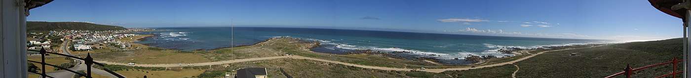
Cape Agulhas has a spectacular coastline, consisting of a gradually curving coastline with rocky and sand beaches. A survey marker and a new ikon depicting the African continent are located at the most Southern tip of Africa. The waters of the Agulhas Bank off the coast are quite shallow and are renowned as one of the best fishing grounds in South Africa.[4][5]
The rocks that form Cape Agulhas belong to the Table Mountain Group, often loosely termed the Table Mountain sandstone. They are closely linked to the geological formations that are exposed in the spectacular cliffs of Table Mountain, Cape Point and the Cape of Good Hope.
Climate
Cape Agulhas has a warm Mediterranean climate (Köppen climate classification:Csb ). The climate is consistently mild, with no temperature or rainfall extremes. According to South African National Parks, who administer the nature reserve, the average rainfall is 400–600 mm per annum, mostly received in winter.[6] Temperature climate data is available for Cape Agulhas, averages are:
| Climate data for Cape Agulhas | |||||||||||||
|---|---|---|---|---|---|---|---|---|---|---|---|---|---|
| Month | Jan | Feb | Mar | Apr | May | Jun | Jul | Aug | Sep | Oct | Nov | Dec | Year |
| Record high °C (°F) | 28.9 (84) |
36.1 (97) |
35.0 (95) |
35.6 (96.1) |
33.9 (93) |
30.0 (86) |
29.4 (84.9) |
31.7 (89.1) |
32.2 (90) |
26.1 (79) |
30.6 (87.1) |
30.6 (87.1) |
36.1 (97) |
| Average high °C (°F) | 23.3 (73.9) |
23.3 (73.9) |
22.2 (72) |
20.6 (69.1) |
18.9 (66) |
17.2 (63) |
16.1 (61) |
17.2 (63) |
17.2 (63) |
18.9 (66) |
20.6 (69.1) |
22.2 (72) |
19.8 (67.6) |
| Daily mean °C (°F) | 20.3 (68.5) |
20.3 (68.5) |
19.2 (66.6) |
17.5 (63.5) |
15.8 (60.4) |
14.2 (57.6) |
13.1 (55.6) |
13.9 (57) |
14.2 (57.6) |
15.8 (60.4) |
17.8 (64) |
19.2 (66.6) |
16.8 (62.2) |
| Average low °C (°F) | 17.2 (63) |
17.2 (63) |
16.1 (61) |
14.4 (57.9) |
12.8 (55) |
11.1 (52) |
10.0 (50) |
10.6 (51.1) |
11.1 (52) |
12.8 (55) |
15.0 (59) |
16.1 (61) |
13.7 (56.7) |
| Record low °C (°F) | 8.3 (46.9) |
8.9 (48) |
9.4 (48.9) |
5.0 (41) |
4.4 (39.9) |
5.6 (42.1) |
3.9 (39) |
4.4 (39.9) |
4.4 (39.9) |
5.0 (41) |
5.0 (41) |
5.0 (41) |
3.9 (39) |
| Average rainfall mm (inches) | 20.3 (0.799) |
17.8 (0.701) |
33.0 (1.299) |
38.1 (1.5) |
50.8 (2) |
58.4 (2.299) |
53.3 (2.098) |
48.3 (1.902) |
40.6 (1.598) |
38.1 (1.5) |
27.9 (1.098) |
17.8 (0.701) |
444.4 (17.496) |
| Average rainy days | 1 | 1 | 3 | 3 | 4 | 4 | 4 | 3 | 3 | 2 | 2 | 1 | 36 |
| Average relative humidity (%) | 77 | 79 | 83 | 84 | 81 | 80 | 80 | 82 | 81 | 79 | 79 | 77 | 80 |
| Source #1: Sistema de Clasificación Bioclimática Mundial[7] | |||||||||||||
| Source #2: Weatherbase[8] | |||||||||||||
Shipping hazards
The sea off Cape Agulhas is notorious for winter storms and mammoth rogue waves, which can range up to 30 metres (100 ft) high and can sink even large ships.[9] Over the past few hundred years it has been believed that around 150 ships have sunk around Agulhas.[10] These conditions are caused by a number of factors. The naturally strong winds of the roaring forties, which blow from west to east, and the cold Antarctic Circumpolar Current flowing in the same direction, come up against the warmer Agulhas Current in the region of the cape. These conflicting currents of water of different densities, and the west winds blowing against the Agulhas Current, can create extremely hazardous wave conditions; these are further exacerbated by the shallow waters of the Agulhas Bank, a broad, shallow part of the continental shelf which juts 250 kilometres (155 mi) south from the cape, after which it falls steeply away to the abyssal plain.
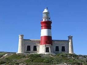
These hazards have combined to make the cape notorious among sailors. The coast here is littered with wrecks: Arniston (1815), Cooranga (1964), Elise (1879), Federal Lakes (1975), Geortyrder (1849), Gouritz (1981), and Gwendola (1968) are just a few of the vessels lost in the proximity of the "Cape of Needles".[11] Owing to the hazards and following the loss of several vessels, notably the Arniston, a lighthouse was built in 1848.[12] The lighthouse now plays host to a museum and a small rustic restaurant.
See also
- Cape Agulhas Local Municipality, the municipality containing Cape Agulhas.
- Agulhas National Park
- Cape of Good Hope, near Cape Town, often incorrectly regarded as the southernmost point of Africa.
- SS Wafra oil spill
- Cape Agulhas Lighthouse
References
- ↑ Limits of Oceans and Seas. International Hydrographic Organization Special Publication No. 23, 1953.
- ↑ Patricia Seed: Discovery of the Coincidence of Magnetic and True North
- ↑ Cape Agulhas Municipality official home page
- ↑ Murray Williams (12 April 2014). "Fury over great white shark haul".
- ↑ Cacutt, Lenn (2000). The Big-Game Fishing Handbook. pp. 145–157.
- ↑ "Agulhas National Park".
- ↑ "South Africa - Cape Agulhas". Centro de Investigaciones Fitosociológicas. Retrieved 2 December 2013.
- ↑ "Climate Statistics for Cape Agulhas, South Africa". Retrieved 22 February 2012.
- ↑ "Rogue Waves – Monsters of the deep: Huge, freak waves may not be as rare as once thought". Economist Magazine. September 17, 2009. Retrieved 2009-10-04.
- ↑ "Visiting the southernmost point in Africa". Villa Tuscana Travel Blog. Retrieved 2016-03-08.
- ↑ Marine Casualty Database Southern African Coast (copy at the Internet Archive), from NCS Cape Town
- ↑ "History: Proposals for a Lighthouse at L'Agulhas". L'Agulhas web site. 29 July 2005. Archived from the original on 19 October 2007. Retrieved 15 November 2007.
External links
Coordinates: 34°49′59.6″S 20°00′0″E / 34.833222°S 20.00000°E