Kintyre, North Dakota
| Kintyre, North Dakota | |
|---|---|
| Unincorporated community | |
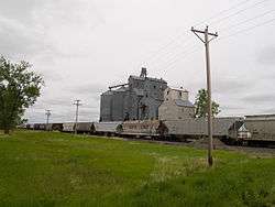 The town's grain elevator, with a DMVW train parked at the terminal in the foreground | |
 Kintyre Location within the state of North Dakota  Kintyre Kintyre (the US) | |
| Coordinates: 46°32′59″N 99°56′58″W / 46.54972°N 99.94944°WCoordinates: 46°32′59″N 99°56′58″W / 46.54972°N 99.94944°W | |
| Country | United States |
| State | North Dakota |
| County | Emmons |
| Elevation | 2,756 ft (840 m) |
| Time zone | UTC-6 (Central (CST)) |
| • Summer (DST) | UTC-5 (CDT) |
| ZIP codes | 58549 |
| Area code(s) | 701 |
| GNIS feature ID | 1034862 |
Kintyre (also Campbell) is an unincorporated community in northeastern Emmons County, North Dakota, United States. It lies northeast of the city of Linton, the county seat of Emmons County.[1] Its elevation is 2,756 feet (840 m). The community was originally named Campbell for Dugald and Hugh Campbell, brothers who ranched there; it is now named Kintyre for the Kintyre Peninsula in Argyll, Scotland.[2] Although it is unincorporated, it has a post office, with the ZIP code of 58549.[3]
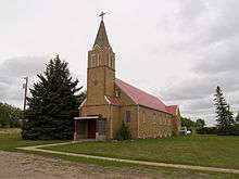
Trinity Lutheran Church
References
- ↑ Rand McNally. The Road Atlas '08. Chicago: Rand McNally, 2008, p. 77.
- ↑ U.S. Geological Survey Geographic Names Information System: Kintyre, North Dakota, Geographic Names Information System, 1980-02-13. Accessed 2008-03-28.
- ↑ Zip Code Lookup
External links
Municipalities and communities of Emmons County, North Dakota, United States | ||
|---|---|---|
| Cities | 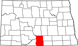 | |
| Township | ||
| Unincorporated communities | ||
This article is issued from
Wikipedia.
The text is licensed under Creative Commons - Attribution - Sharealike.
Additional terms may apply for the media files.