Point Calimere
Coordinates: 10°17′16″N 79°51′54″E / 10.2878°N 79.8651°E

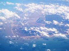
Kodiakkarai also called Point Calimere or Cape Calimere, (Tamil: கோடியக்கரை Kodiakkarai), is a low headland on the Coromandel Coast, in the Nagapattinam district of the state of Tamil Nadu, India. It is the apex of the Cauvery River delta, and marks a nearly right-angle turn in the coastline. A historic landmark here was the Chola lighthouse, destroyed in the tsunami of 2004. It is designated as Ramsar Convention since August 2002.
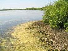
The forests of Point Calimere, also known the Vedaranyam[1] forests, are one of the last remnants of the dry evergreen forests that were once typical of the East Deccan dry evergreen forests ecoregion. The Point Calimere Wildlife Sanctuary, with an area of 24.17 km2, was created on June 13, 1967. The sanctuary includes the cape and its three natural habitat types: dry evergreen forests, mangrove forests, and wetlands. In 1988, the sanctuary was enlarged to include the Great Vedaranyam Swamp and the Talaignayar Reserve Forest, and renamed the Point Calimere Wildlife and Bird Sanctuary, with a total area of 377 km2. Point Calimere is home to the endangered endemic Indian blackbuck and is one of the few known wintering locations of the spoon-billed sandpiper.[2] It also holds large wintering populations of greater flamingos in India. The area is dotted with salt pans and these hold large crustacean populations that support the wintering bird life. Pesticide residues running off from agricultural fields and shrimp farms has entered the ecosystem and many species have high concentrations of DDT and HCH in their tissue.[3]
Not far from Point Calimere is the mangrove forest of Muthupet.
Point Calimere is also associated with the mythological Hindu epic, The Ramayana. The highest point of the cape, at an elevation of 4 m, is Ramarpatham,"Rama’s feet" in Tamil. A stone slab bears the impressions of two feet and is understood to be the place where Rama stood and reconnoitered Ravana’s kingdom in Sri Lanka, which lies 48 km. to the south.
Cultural Heritage
Several sites of religious, historical or cultural importance are located within the sanctuary:
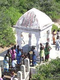
- Ramar Padam (literally: Ramas Footprint) located on the highest point of land in the sanctuary, is a small shrine containing the stone footprints of Lord Rama. Large numbers of Rama devotees gather here during the second week of April to celebrate Ram Navami Festival.
- Navakodi Sitthar Aalayam is a temple in south of the Kodiakkarai village. The history of this temple is the wedding ceremony of Lord Shiva and Parvathy ammaal have been attended by lot many Sitthars at this location. Chola Emperor and Mannar Sarafoji were visited this temple. A small village called "Kanakkar Madam" near this shrine was demolished around 80 years ago and the people who were living there are relocated to Kodiakkarai village and they are still called as Kanakkarmadathiaar's family. A large congregation of devotees from all over Tamil Nadu state to come on special day of Amaavasai/Pournami to celebrate a special festival here every year. The greatest lord and the environment gives the peace like never ever feel.
- Sanyasin Muniaswar Kovil is a shrine between the eastern bank of Muniappan Lake and Kodiakkarai Road visited by devotees on all auspicious occasions. On March 20 a special Puja is celebrated here.
- Mattumunian Kovil is a small temple in the south of the sanctuary where people worship and offer prayers throughout the year. A major festival occurs here on the 3rd Friday of September.
- Modi Mandapam is a shrine located near Ramar Padam where people of all castes worship. Hindu legend says that Lord Vedaraneswarer spends a night here with his consort during January - February. In the first week of March a major festival is held here.
- Avulaiganni Dargah is the grave of a Muslim saint located near the road by Ramar Padam. His death anniversary is observed here at the end of November.
- Shevrayan Kovil is a shrine to the deities Shevrayan and Soni located deep in the forests of the northern part of the sanctuary. A small village near this shrine was relocated outside the sanctuary after the creation of Kodiakkarai Reserve Forest. A large congregation of devotees from Arcothurai celebrate a special festival here in June/July.
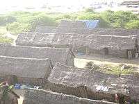
- Adivasi Colony is a community of Ambalakars living in huts of mud, coconut fronds and palmyrah leaves on the edge of Kodiakkarai village. Their traditional livelihood was the collection of non-timber forest products in the areas that are now the sanctuary. These practices are now prohibited but not fully eliminated. Many of these people catch fish and small prawns in the nearby mudflats and swamps. Some work as day labourers in the nearby salt pans. They have little interaction with other communities on the island.
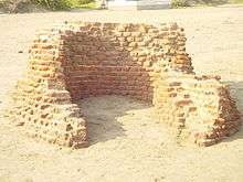
- Chola Lighthouse is the remains of a brick and mortar lighthouse near Point Calimere said to have been built by the Cholas more than a thousand years ago. This structure was badly damaged by the 2004 Indian Ocean Tsunami but can still be seen in the intertidal zone near the British lighthouse.[4]
- British Lighthouse is a 13-metre (43 ft) tall operating lighthouse built by the British at the tip of Point Calemere in 1890 and can be seen 13 nautical miles (24 km; 15 mi) at sea.[5]
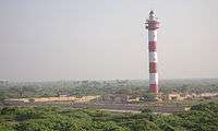
- Kodiakkarai Lighthouse is a 45-metre (148 ft) tall modern aid to navigation located near Kodiakkarai Beach and is accessible to the public between 1500 - 1700hrs. This dominates the sanctuary and may be seen by seamen far at sea.[4]
See also
References
- ↑ See Vedaranyam#Geography. And from source: Thiruthuraipoondi#Geography: Satellite pictures and carbon dating of some ancient beaches between Thiruthuraipoondi and Kodiyakarai show the Thiruthuraipoondi beach dates back 6,000 years and the Kodiyakarai beach 1,100 years. In other words, the sea was near Thiruthuraipoondi 6,000 years ago and reached Kodiyakarai around 1,100 years ago.
- ↑ Sharma, Arunayan (2003). "First records of Spoon-billed Sandpiper Calidris pygmeus in the Indian Sundarbans delta, West Bengal" (PDF). Forktail. 19: 136–137.
- ↑ Sethuraman, A and AN Subramanian (2003). "Organochlorine residues in the avifauna of Tamil Nadu (Southeast coast of India)". Chemistry and Ecology. 19 (4): 247–261. doi:10.1080/02757540310001596843.
- 1 2 Arauah A.D. (March 2005). Point Calimere Wildlife & Bird Sanctuary - A Ramsar Site. District Collectorate Campus 329, 3rd Floor, Nagapattinam, Tamil Nadu 611002 India: Tamil Nadu Forest Department, Wildlife Warden. p. 180 illus. color.
|access-date=requires|url=(help) - ↑ "Welcome to POINT CALIMERE LIGHT HOUSE". Directorate General of Lighthouses and Ships. Retrieved 2008-09-20.
| District Headquarters |  | |
|---|---|---|
| Country | ||
| State | ||
| Region | ||
| Divisions | ||
| Taluks | ||
| Revenue blocks | ||
| Municipalities | ||
| Rivers | ||
| History | ||
| Places of interest |
| |
| Religious and monastic institutions | ||
| ||