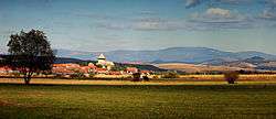
Cața
| Cața Kaca | |
|---|---|
| Commune | |
 | |
 | |
 Cața | |
| Coordinates: 46°5′N 25°16′E / 46.083°N 25.267°E | |
| Country |
|
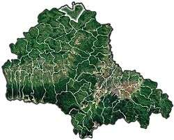
| County | Brașov County |
| Area | 118.12 km2 (45.61 sq mi) |
| Population (2011)[1] | 2,399 |
| Time zone | UTC+2 (EET) |
| • Summer (DST) | UTC+3 (EEST) |
Cața (German: Katzendorf; Hungarian: Kaca) is a commune in Brașov County, Romania. It is composed of five villages: Beia, Cața, Drăușeni, Ionești and Paloș. There are three fortified churches in the commune, at Cața, Beia and Drăușeni.
At the 2011 census, 44.9% of inhabitants were Romanians, 30.9% Hungarians and 23.4% Roma.
| In Romanian | In German | In Hungarian |
|---|---|---|
| Beia | Meeburg | Homoródbene |
| Cața | Katzendorf | Kaca |
| Drăușeni | Draas | Homoróddaróc |
| Ionești | Eisdorf | Homoródjánosfalva |
| Paloș | Königsdorf | Pálos |
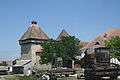 Fortified church of Cața
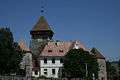 Fortified church of Drăușeni
References
- ↑ Romanian census data, 2011 Archived July 23, 2013, at the Wayback Machine.; retrieved on March 17, 2012
This article is issued from
Wikipedia.
The text is licensed under Creative Commons - Attribution - Sharealike.
Additional terms may apply for the media files.