Burgeo
| Burgeo | ||
|---|---|---|
| Town | ||
 | ||
| ||
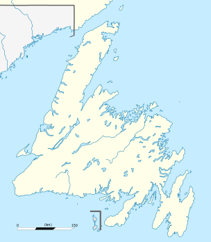 Burgeo Location of Burgeo in Newfoundland | ||
| Coordinates: 47°36′00″N 57°38′00″W / 47.60000°N 57.63333°W | ||
| Country |
| |
| Province |
| |
| Government | ||
| • Mayor | John Savoury | |
| • MHA | Andrew Parsons (Burgeo and La Poile) | |
| • MP | Gudie Hutchings (Long Range Mountains) | |
| Population (2016) | ||
| • Total | 1,307[1] | |
| Time zone | UTC-3:30 (Newfoundland Time) | |
| • Summer (DST) | UTC-2:30 (Newfoundland Daylight) | |
| Area code(s) | 709 | |
.jpg)
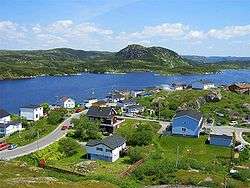
Burgeo is a Canadian town located on the south coast of the island of Newfoundland in the province of Newfoundland and Labrador.
The town is approximately 75 miles (121 km) east of Channel-Port aux Basques. Burgeo is home to Sandbanks Provincial Park. The park is named for its sand dunes and long expanses of flat, sandy beaches which are some of the most magnificent on the island portion of Newfoundland and Labrador.[2]
Demographics
The population was 900 in 1911, 2,474 in 1976, 1,607 in 2006, 1,464 in 2011 and 1,307 in 2016. [1]
Notable people
The famed Canadian nature writer and naturalist Farley Mowat lived in Burgeo for 5 years during his time in Newfoundland.
Transport Links
There is a ferry dock with connections to Ramea, Grey River and Francois.[3]
Climate
| Climate data for Burgeo | |||||||||||||
|---|---|---|---|---|---|---|---|---|---|---|---|---|---|
| Month | Jan | Feb | Mar | Apr | May | Jun | Jul | Aug | Sep | Oct | Nov | Dec | Year |
| Record high °C (°F) | 8.7 (47.7) |
8.9 (48) |
9.2 (48.6) |
14.8 (58.6) |
21.7 (71.1) |
24.4 (75.9) |
25.9 (78.6) |
26.7 (80.1) |
23.1 (73.6) |
18.6 (65.5) |
14.4 (57.9) |
11.5 (52.7) |
26.7 (80.1) |
| Average high °C (°F) | −1.4 (29.5) |
−2 (28) |
0.5 (32.9) |
4.5 (40.1) |
8.8 (47.8) |
12.6 (54.7) |
16.5 (61.7) |
18.1 (64.6) |
15.2 (59.4) |
10.3 (50.5) |
5.8 (42.4) |
1.3 (34.3) |
7.5 (45.5) |
| Average low °C (°F) | −8.4 (16.9) |
−9.4 (15.1) |
−6.4 (20.5) |
−1.5 (29.3) |
2.4 (36.3) |
6.4 (43.5) |
10.5 (50.9) |
11.4 (52.5) |
7.8 (46) |
3.4 (38.1) |
−0.3 (31.5) |
−5.4 (22.3) |
0.9 (33.6) |
| Record low °C (°F) | −19.4 (−2.9) |
−25.6 (−14.1) |
−25.2 (−13.4) |
−12.2 (10) |
−7.2 (19) |
1.1 (34) |
4.4 (39.9) |
3.9 (39) |
−0.6 (30.9) |
−4.7 (23.5) |
−12.9 (8.8) |
−18.3 (−0.9) |
−25.6 (−14.1) |
| Average precipitation mm (inches) | 156.7 (6.169) |
130.5 (5.138) |
128.1 (5.043) |
131.6 (5.181) |
125.2 (4.929) |
149.3 (5.878) |
139.9 (5.508) |
138.5 (5.453) |
133.2 (5.244) |
156.9 (6.177) |
175.5 (6.909) |
173.8 (6.843) |
1,739.2 (68.472) |
| Source: 1961-1990 Environment Canada [4] | |||||||||||||
See also
References
- 1 2 "Burgeo Census". Statistics Canada. Retrieved 30 June 2018.
- ↑ http://www.env.gov.nl.ca/env/parks/parks/p_sp/
- ↑ "Burgeo". Town of Burgeo. Retrieved 17 March 2018.
- ↑ Environment Canada—Canadian Climate Normals 1961–1990. Retrieved 7 October 2012.
External links
| Wikivoyage has a travel guide for Burgeo. |
Coordinates: 47°36′N 57°38′W / 47.600°N 57.633°W