Broad Top City, Pennsylvania
| Broad Top City, Pennsylvania | |
|---|---|
| Borough | |
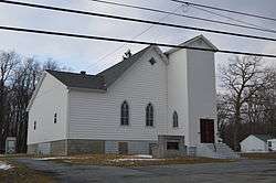 Church of Christ on Railroad Avenue | |
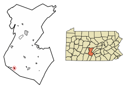 Location of Broad Top City in Huntingdon County, Pennsylvania. | |
 Broad Top City Location of Broad Top City in Huntingdon County, Pennsylvania.  Broad Top City Broad Top City (the US) | |
| Coordinates: 40°12′06″N 78°08′23″W / 40.20167°N 78.13972°WCoordinates: 40°12′06″N 78°08′23″W / 40.20167°N 78.13972°W | |
| Country | United States |
| State | Pennsylvania |
| County | Huntingdon |
| Government | |
| • Type | Borough Council |
| • Mayor | Nathan Neville (R) |
| Area[1] | |
| • Total | 0.68 sq mi (1.75 km2) |
| • Land | 0.68 sq mi (1.75 km2) |
| • Water | 0.00 sq mi (0.00 km2) |
| Elevation | 1,975 ft (602 m) |
| Population (2010) | |
| • Total | 452 |
| • Estimate (2016)[2] | 444 |
| • Density | 655.83/sq mi (253.30/km2) |
| Time zone | UTC-5 (Eastern (EST)) |
| • Summer (DST) | UTC-4 (EDT) |
| ZIP code | 16621 |
| Area code(s) | 814 |
| FIPS code | 42-08896 |
| Local phone exchanges: 635 | |
Broad Top City is a borough in Huntingdon County, Pennsylvania, United States. The population was 452 at the 2010 census,[3] up from 384 at the 2000 census.
Geography
Broad Top City is located in southwestern Huntingdon County at 40°12′6″N 78°8′23″W / 40.20167°N 78.13972°W (40.201593, -78.139631).[4] It is bordered to the north, west, and south by Carbon Township and to the east by Wood Township. The borough sits on top of a plateau at an elevation of 1,970 feet (600 m) above sea level.
Pennsylvania Route 913 passes through the center of the borough, leading west 2.5 miles (4.0 km) to Dudley and southeast 2 miles (3 km) to Robertsdale, downhill in both directions.
According to the United States Census Bureau, the borough has a total area of 0.68 square miles (1.75 km2), all of it land.[3]
Demographics
| Historical population | |||
|---|---|---|---|
| Census | Pop. | %± | |
| 1870 | 327 | — | |
| 1880 | 298 | −8.9% | |
| 1890 | 240 | −19.5% | |
| 1900 | 258 | 7.5% | |
| 1910 | 478 | 85.3% | |
| 1920 | 519 | 8.6% | |
| 1930 | 511 | −1.5% | |
| 1940 | 610 | 19.4% | |
| 1950 | 483 | −20.8% | |
| 1960 | 334 | −30.8% | |
| 1970 | 283 | −15.3% | |
| 1980 | 340 | 20.1% | |
| 1990 | 331 | −2.6% | |
| 2000 | 384 | 16.0% | |
| 2010 | 452 | 17.7% | |
| Est. 2016 | 444 | [2] | −1.8% |
| Sources:[5][6][7] | |||
As of the census[6] of 2000, there were 384 people, 162 households, and 117 families residing in the borough. The population density was 600.8 people per square mile (231.7/km²). There were 178 housing units at an average density of 278.5 per square mile (107.4/km²). The racial makeup of the borough was 100.00% White.
There were 162 households, out of which 30.9% had children under the age of 18 living with them, 58.0% were married couples living together, 8.0% had a female householder with no husband present, and 27.2% were non-families. 24.7% of all households were made up of individuals, and 14.8% had someone living alone who was 65 years of age or older. The average household size was 2.37 and the average family size was 2.80.
In the borough the population was spread out, with 20.6% under the age of 18, 7.8% from 18 to 24, 24.2% from 25 to 44, 30.7% from 45 to 64, and 16.7% who were 65 years of age or older. The median age was 43 years. For every 100 females there were 106.5 males. For every 100 females age 18 and over, there were 100.7 males.
The median income for a household in the borough was $27,500, and the median income for a family was $33,056. Males had a median income of $28,438 versus $21,250 for females. The per capita income for the borough was $12,788. About 21.2% of families and 19.8% of the population were below the poverty line, including 19.8% of those under age 18 and 3.6% of those age 65 or over.
References
- ↑ "2016 U.S. Gazetteer Files". United States Census Bureau. Retrieved Aug 14, 2017.
- 1 2 "Population and Housing Unit Estimates". Retrieved June 9, 2017.
- 1 2 "Geographic Identifiers: 2010 Census Summary File 1 (G001): Broad Top City borough, Pennsylvania". American Factfinder. U.S. Census Bureau. Retrieved January 17, 2018.
- ↑ "US Gazetteer files: 2010, 2000, and 1990". United States Census Bureau. 2011-02-12. Retrieved 2011-04-23.
- ↑ "Census of Population and Housing". U.S. Census Bureau. Archived from the original on 12 May 2015. Retrieved 11 December 2013.
- 1 2 "American FactFinder". United States Census Bureau. Archived from the original on 2013-09-11. Retrieved 2008-01-31.
- ↑ "Incorporated Places and Minor Civil Divisions Datasets: Subcounty Resident Population Estimates: April 1, 2010 to July 1, 2012". Population Estimates. U.S. Census Bureau. Archived from the original on 17 June 2013. Retrieved 11 December 2013.
Municipalities and communities of Huntingdon County, Pennsylvania, United States | ||
|---|---|---|
| Boroughs |  | |
| Townships | ||
| CDPs | ||
| Unincorporated communities | ||
| Ghost town | ||
| Footnotes | ‡This populated place also has portions in an adjacent county or counties | |