Bridalveil Fall
| Bridalveil Fall | |
|---|---|
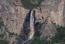 Bridalveil Fall as seen from Tunnel View on California State Route 41. | |
| Location | Yosemite Valley, Yosemite National Park, California. |
| Type | Plunge |
| Total height | 188 metres (617 ft) |
| Number of drops | 1 |
| World height ranking | 431 |
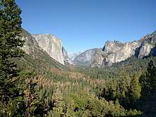
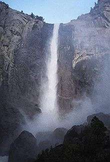
Bridalveil Fall is one of the most prominent waterfalls in the Yosemite Valley in California, Yosemite National Park.[1] The waterfall is 188 metres (617 ft) in height and flows year round.[2]
Geology
The glaciers that carved Yosemite Valley left many hanging valleys that spawned the waterfalls that pour into the valley. All of the waterways that fed these falls carved the hanging valleys into steep cascades with the exception of Bridalveil Fall. Bridalveil Creek still leaps into the valley from the edge of the precipice, although that edge has moved back into an alcove from the original edge of the valley. While Yosemite Falls seem to also fall into this category, the original course took the Yosemite Creek down a gorge to the west of its current location.[3] The primary source of Bridalveil Falls is Ostrander Lake, some 16 kilometres (9.9 mi) to the south.
In a brisk wind, the falling water is often blown sideways, and when the flow is light, it may not reach the ground directly below. Because of this, the Ahwahneechee Native Americans called this waterfall "Pohono", which means "Spirit of the Puffing Wind".[4]
See also
References
- ↑ The official name is singular, see U.S. Geological Survey Geographic Names Information System: Bridalveil Fall.
- ↑ "Things to see". Yosemite National Park. Archived from the original on 2005-08-31. Retrieved 2005-09-20.
- ↑ N. King Huber. "The Geologic Story of Yosemite Valley". USGS Western Region Geologic Information. Retrieved 2008-09-16.
- ↑ Kroeber, A.L. (1993). Indians of Yosemite. Berkeley: California Indian Library Collections [distributor]. OCLC 58867540. Retrieved 2008-09-16.
External links
| Wikimedia Commons has media related to Bridalveil Fall. |
- U.S. Geological Survey Geographic Names Information System: Bridalveil Fall
- Story of Bridalveil Fall, Pohono Indian legend.
Coordinates: 37°43′00″N 119°38′47″W / 37.716753°N 119.646505°W
| Attractions |
| |||||
|---|---|---|---|---|---|---|
| People | ||||||
| Lodging & camping | ||||||
| Natural disasters | ||||||
| Transportation | ||||||
| Nearby municipalities | ||||||
| Additional information |
| |||||
| ||||||
