Brewton, Alabama
| Brewton, Alabama | |
|---|---|
| City | |
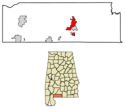 Location of Brewton in Escambia County, Alabama. | |
| Coordinates: 31°7′3″N 87°4′16″W / 31.11750°N 87.07111°W | |
| Country | United States |
| State | Alabama |
| County | Escambia |
| Government | |
| • Mayor | Yank Lovelace |
| Area[1] | |
| • Total | 11.45 sq mi (29.65 km2) |
| • Land | 11.22 sq mi (29.05 km2) |
| • Water | 0.23 sq mi (0.60 km2) |
| Elevation | 82 ft (25 m) |
| Population (2010) | |
| • Total | 5,408 |
| • Estimate (2017)[2] | 5,236 |
| • Density | 466.83/sq mi (180.24/km2) |
| Time zone | UTC-6 (Central (CST)) |
| • Summer (DST) | UTC-5 (CDT) |
| ZIP code | 36426-36427 |
| Area code(s) | 251 |
| FIPS code | 01-09208 |
| GNIS feature ID | 0157900 |
| Interstates |
|
| U.S. Routes |
|
| Website | http://www.cityofbrewton.org/ |
Brewton is a city in Escambia County, Alabama, United States. At the 2010 census, the population was 5,408. The city is the county seat of Escambia County. Brewton is located in south central Alabama, just north of the Florida Panhandle. Brewton has been voted one of the 100 best small towns in America in Norman Crampton's book, "The 100 Best Small Towns in America".[3]
History

In May 1861, the city of Brewton began as a train station under Edmund Troupe Bruton. The settlement was originally known as Newport when barges made runs to and from Pensacola, Florida on Murder Creek and Burnt Corn Creek before the installation of rail.
During the Civil War rail lines were severed, and small lumber mills were damaged or destroyed. However, after the war those who returned or arrived rebuilt the Brewton economy, began a school, and established small businesses. Into the 1870s a new European demand for lumber opened the way for creation of numerous timber and lumber operations. The Conecuh-Escambia river system became a timber artery to the Gulf.
Brewton became a town on February 13, 1885 and later became the seat of Escambia County, Alabama.
Brewton was known in past times as "the richest little town in the South." Brewton's high per capita income was created by a small number of "timber barons," as they are remembered, who arrived at the end of the last century to cut pine and stayed to build extraordinary homes along Belleville and Evergreen avenues. These families include the McMillans and the Millers, many of whom still reside in the town.
Over time the county erected a series of courthouses. Brewton developed an education system that included public and private institutions, including Jefferson Davis Community College and T. R. Miller High School, named for Thomas Richard Miller, a local timber baron and town father who contributed money toward the building and opening of the school.
In October 1934, Claude Neal, an African-American man arrested for the murder of a local white woman in Greenwood, Florida, was moved to the jail in Brewton, Alabama for safekeeping. After a lynch mob found out where he was being held, however, they descended upon Brewton and kidnapped him from the jail. He was smuggled back into Jackson County, Florida, where he was lynched.
Geography
Brewton is located at 31°7′4″N 87°4′16″W / 31.11778°N 87.07111°W (31.117706, -87.071164).[4]
According to the U.S. Census Bureau, the city has a total area of 11.5 square miles (30 km2), of which 11.3 square miles (29 km2) is land and 0.1 square miles (0.26 km2) (1.22%) is water.
Climate
Climate is characterized by relatively high temperatures and evenly distributed precipitation throughout the year. The Köppen Climate Classification sub-type for this climate is "Cfa" (Humid Subtropical Climate).[5] The hottest temperature ever recorded in the city was 109 °F (43 °C) on June 18, 1933,[6] and the coldest temperature ever recorded was 3 °F (−16 °C) on January 21, 1985.[6]
| Climate data for Brewton, Alabama (Brewton 3 SSE), 1981–2010 normals | |||||||||||||
|---|---|---|---|---|---|---|---|---|---|---|---|---|---|
| Month | Jan | Feb | Mar | Apr | May | Jun | Jul | Aug | Sep | Oct | Nov | Dec | Year |
| Record high °F (°C) | 87 (31) |
96 (36) |
91 (33) |
95 (35) |
100 (38) |
109 (43) |
106 (41) |
104 (40) |
102 (39) |
98 (37) |
89 (32) |
84 (29) |
109 (43) |
| Average high °F (°C) | 61.6 (16.4) |
65.5 (18.6) |
72.5 (22.5) |
78.6 (25.9) |
85.1 (29.5) |
89.7 (32.1) |
91.6 (33.1) |
91.0 (32.8) |
87.1 (30.6) |
79.4 (26.3) |
71.4 (21.9) |
63.5 (17.5) |
78.1 (25.6) |
| Average low °F (°C) | 35.7 (2.1) |
38.5 (3.6) |
43.8 (6.6) |
49.7 (9.8) |
58.5 (14.7) |
66.1 (18.9) |
69.3 (20.7) |
69.3 (20.7) |
63.6 (17.6) |
51.9 (11.1) |
43.0 (6.1) |
37.8 (3.2) |
52.3 (11.3) |
| Record low °F (°C) | 3 (−16) |
11 (−12) |
10 (−12) |
25 (−4) |
34 (1) |
40 (4) |
55 (13) |
53 (12) |
32 (0) |
21 (−6) |
15 (−9) |
7 (−14) |
3 (−16) |
| Average precipitation inches (mm) | 5.89 (149.6) |
5.42 (137.7) |
6.27 (159.3) |
4.70 (119.4) |
4.86 (123.4) |
5.91 (150.1) |
6.67 (169.4) |
6.30 (160) |
5.74 (145.8) |
3.75 (95.3) |
5.28 (134.1) |
4.76 (120.9) |
65.54 (1,664.7) |
| Average precipitation days (≥ 0.01 in) | 8.5 | 7.6 | 7.0 | 5.8 | 7.4 | 10.0 | 11.7 | 11.2 | 7.6 | 5.4 | 6.5 | 7.4 | 96.1 |
| Source: NOAA (extremes 1926–present)[6] | |||||||||||||
Demographics
| Historical population | |||
|---|---|---|---|
| Census | Pop. | %± | |
| 1890 | 1,115 | — | |
| 1900 | 1,382 | 23.9% | |
| 1910 | 2,185 | 58.1% | |
| 1920 | 2,682 | 22.7% | |
| 1930 | 2,818 | 5.1% | |
| 1940 | 3,323 | 17.9% | |
| 1950 | 5,146 | 54.9% | |
| 1960 | 6,309 | 22.6% | |
| 1970 | 6,747 | 6.9% | |
| 1980 | 6,680 | −1.0% | |
| 1990 | 5,885 | −11.9% | |
| 2000 | 5,498 | −6.6% | |
| 2010 | 5,408 | −1.6% | |
| Est. 2017 | 5,236 | [2] | −3.2% |
| U.S. Decennial Census[7] 2013 Estimate[8] | |||
As of the census[9] of 2000, there were 5,498 people, 2,216 households, and 1,471 families residing in the city. The population density was 485.2 people per square mile (187.4/km2). There were 2,543 housing units at an average density of 224.4 per square mile (86.7/km2). The racial makeup of the city was 57.60% White or Caucasian, 40.23% Black or African American, 0.42% Native American, 0.49% Asian, 0.53% from other races, and 0.73% from two or more races. 1.11% of the population were Hispanic or Latino of any race.
There were 2,216 households out of which 27.5% had children under the age of 18 living with them, 46.3% were married couples living together, 17.1% had a female householder with no husband present, and 33.6% were non-families. 31.0% of all households were made up of individuals and 15.6% had someone living alone who was 65 years of age or older. The average household size was 2.35 and the average family size was 2.95.
In the city, the population was spread out with 23.8% under the age of 18, 7.1% from 18 to 24, 24.1% from 25 to 44, 25.5% from 45 to 64, and 19.6% who were 65 years of age or older. The median age was 42 years. For every 100 females, there were 85.2 males. For every 100 females age 18 and over, there were 79.1 males.
The median income for a household in the city was $34,234, and the median income for a family was $43,548. Males had a median income of $37,348 versus $20,212 for females. The per capita income for the city was $18,185. About 12.6% of families and 16.3% of the population were below the poverty line, including 25.3% of those under age 18 and 18.4% of those age 65 or over.
2010 census
As of the census[10] of 2010, there were 5,408 people, 2,171 households, and 1,412 families residing in the city. The population density was 474.9 people per square mile (182.1/km2). There were 2,522 housing units at an average density of 221.2 per square mile (84.9/km2). The racial makeup of the city was 54.1% White or Caucasian, 42.6% Black or African American, 0.7% Native American, 0.4% Asian, 1.1% from other races, and 1.0% from two or more races. 2.2% of the population were Hispanic or Latino of any race.
There were 2,171 households out of which 25.6% had children under the age of 18 living with them, 41.1% were married couples living together, 19.6% had a female householder with no husband present, and 35.0% were non-families. 32.0% of all households were made up of individuals and 16.3% had someone living alone who was 65 years of age or older. The average household size was 2.36 and the average family size was 2.97.
In the city, the population was spread out with 22.7% under the age of 18, 7.8% from 18 to 24, 22.4% from 25 to 44, 27.9% from 45 to 64, and 19.2% who were 65 years of age or older. The median age was 42.4 years. For every 100 females, there were 86.2 males. For every 100 females age 18 and over, there were 96.8 males.
The median income for a household in the city was $34,390, and the median income for a family was $49,554. Males had a median income of $35,233 versus $28,879 for females. The per capita income for the city was $20,467. About 19.6% of families and 22.3% of the population were below the poverty line, including 41.3% of those under age 18 and 7.9% of those age 65 or over.
Government
The city government consists of a part-time mayor elected at-large and a five-member part-time city council elected from districts. Brewton utilizes a city school system.
Culture and special events
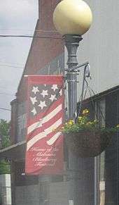
The annual Alabama Blueberry Festival is held at Jennings Park and downtown Brewton. Prior to 2006 it was held on the campus of Jefferson Davis Community College.
The Thomas E. McMillan Museum is housed on the campus of the Jefferson Davis Community College.[11] It was founded in 1979 to chronicle life in Escambia County, Alabama. The museum includes items from 10,000-year-old fossils, to a fireside popcorn popper and a display of cameras.
Notable people
- Alan Baker, member of the Alabama House of Representatives
- Sharon Lovelace Blackburn, the first female federal judge appointed in Alabama
- Johnnie Byrd, former member of the Florida House of Representatives
- Grayson Capps, singer-songwriter
- Catherine Crosby, Miss Alabama 2003
- Kristi DuBose, judge on the United States District Court for the Southern District of Alabama
- Wayne Frazier, pro football player, former Auburn University player
- William Lee Golden, member of The Oak Ridge Boys
- Deanna Jackson, professional women's basketball player
- Teddy Keaton, football coach, Stillman College
- Cliff Lewis, former professional football player
- Hank Locklin, country music singer
- Jonathan Bell Lovelace, founder of Capital Group Companies
- Edwin L. Nelson, former judge on the United States District Court for the Northern District of Alabama
- Anthony Redmon, former NFL offensive lineman
- William W. Seay, soldier during the Vietnam War, recipient of the Medal of Honor
- Fred Snowden, former men's basketball coach for the University of Arizona
- Kevin Sumlin, football coach, University of Arizona football
- Richard "Snapper" Thomas, Sr.,(First Black Businessman on Baptist Hill| https://www.brewtonstandard.com/
- Davern Williams, former defensive tackle for the Miami Dolphins and New York Giants
- Edward O. Wilson, two-time Pulitzer prize winner and biologist
Historic sites
Brewton has one site listed on the National Register of Historic Places, the Brewton Historic Commercial District.[12]
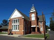
The historic Second Saint Siloam Missionary Baptist Church was established on November 5, 1909 when a group of worshipers gathered at the Congregational Church on the corner of St. Joseph and Evergreen avenues in Brewton to organize a new church. The Second St. Siloam Missionary Baptist Church was dedicated on June 10, 1910 on the corner of East and North streets. On April 1, 2010 the church was added to the Alabama Register of Historic Places.[13]
References
- ↑ "2017 U.S. Gazetteer Files". United States Census Bureau. Retrieved Jul 7, 2018.
- 1 2 "Population and Housing Unit Estimates". Retrieved March 24, 2018.
- ↑ "Brewton Chamber of Commerce". brewtonchamber.com. Retrieved 6 August 2018.
- ↑ "US Gazetteer files: 2010, 2000, and 1990". United States Census Bureau. 2011-02-12. Retrieved 2011-04-23.
- ↑ "Brewton, Alabama Köppen Climate Classification (Weatherbase)". Weatherbase.com. Retrieved 16 January 2018.
- 1 2 3 "NowData — NOAA Online Weather Data". National Oceanic and Atmospheric Administration. Retrieved 2013-11-25.
- ↑ "U.S. Decennial Census". Census.gov. Archived from the original on May 12, 2015. Retrieved June 6, 2013.
- ↑ "Annual Estimates of the Resident Population: April 1, 2010 to July 1, 2013". Archived from the original on May 22, 2014. Retrieved June 3, 2014.
- ↑ "American FactFinder". United States Census Bureau. Archived from the original on 2013-09-11. Retrieved 2008-01-31.
- ↑ "American FactFinder". United States Census Bureau. Archived from the original on 2013-09-11. Retrieved 2015-07-22.
- ↑ "Museum". Museum.jdcc.edu. Retrieved 16 January 2018.
- ↑ National Park Service (July 9, 2010). "National Register Information System". National Register of Historic Places. National Park Service.
- ↑
External links
| Wikimedia Commons has media related to Brewton, Alabama. |
- City of Brewton is the city's website.
- Chamber of Commerce is the local Chamber's website.
- Alabama Blueberry Festival is the festival website.
- Brewton Standard is the local newspaper.
- Coastal Gateway Regional Economic Development Alliance
Coordinates: 31°07′04″N 87°04′16″W / 31.117706°N 87.071164°W
Municipalities and communities of Escambia County, Alabama, United States | ||
|---|---|---|
| Cities |  | |
| Towns | ||
| Unincorporated communities | ||
| Indian reservation | ||