Bremen TV tower
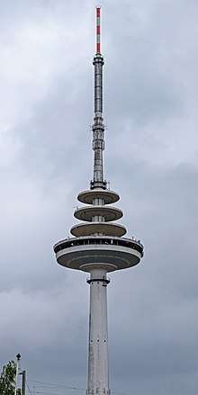
Bremen-Walle Telecommunication Tower (official designation of Bremen TV tower), which is not accessible for the public, is, just like the telecommunication tower at Münster and the Friedrich-Clemens-Gerke Tower in Cuxhaven, a reproduction of the telecommunication tower Kiel (draft: Architect dipl. Ing. Gerhard Kreisel and dipl. Ing. Guenter H. Mueller, Kiel). It is 235.70 meters high. The diameter of the operating pulpit, which is 108.20 meters above ground, is 40 meters. The telecommunication tower is located in the Bremen quarter Walle at the Utbremer road, about 2.5 kilometers northwest from the city center (market place with city hall, pc. Petri cathedral, Roland and the city musicians of Bremen). All FM-radio and TV programs of radio Bremen in Bremen are transmitted today from this tower. A 70 cm amateur radio relay, DB0OZ, with an expenditure frequency of 438.825 MHz, is also on the tower.
In order to furnish the year 2000 it was considered, to install a restaurant in the operating pulpit. These plans were however again rejected.
Transmitted programmes
FM
| Program | Frequency | ERP |
|---|---|---|
| Nordwestradio | 88,3 MHz | 100 kW |
| Energy Bremen | 89,8 MHz | 1 kW |
| 92,5 Der Sender (Bürgerrundfunk Bremen) | 92,5 MHz | 0,2 kW |
| Bremen Eins | 93,8 MHz | 100 kW |
| NDR Info / Radio Bremen Parlamentsradio | 95,0 MHz | 1 kW |
| Funkhaus Europa | 96,7 MHz | 50 kW |
| Deutschlandradio Kultur | 100,3 MHz | 1 kW |
| Bremen Vier | 101,2 MHz | 100 kW |
| Hitradio Antenne | 104,8 MHz | 0,1 kW |
| Deutschlandfunk | 107,1 MHz | 100 kW |
TV
| Channel | Frequency | Programm | Power | Modulation | Erraor Protection mode | Guard | Data rate |
|---|---|---|---|---|---|---|---|
| 22 | 479,25 MHz |
|
32 kW horizontal | 16-QAM | 2/3 | 1/4 | 13,27 Mbit/s (8k-Modus) |
| 32 | 559,25 MHz |
|
32 kW horizontal | 16-QAM | 2/3 | 1/4 | 13,27 MBit/s (8k-Modus) |
| 29 | 535,25 MHz |
|
32 kW horizontal | 16-QAM | 2/3 | 1/4 | 13,27 MBit/s (8k-Modus) |
| 49 | 687,25 MHz |
|
50 kW horizontal | 16-QAM | 2/3 | 1/4 | 13,27 MBit/s (8k-Modus) |
| 42 | 639,25 MHz | 50 kW horizontal | 16-QAM | 2/3 | 1/4 | 13,27 MBit/s (8k-Modus) | |
| 45 | 663,25 MHz | 20 kW horizontal | 16-QAM | 2/3 | 1/4 | 13,27 MBit/s (8k-Modus) |