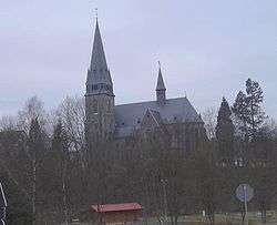
Nonnweiler
| Nonnweiler | ||
|---|---|---|
 | ||
| ||
 Nonnweiler Location of Nonnweiler within Sankt Wendel district 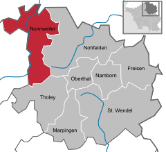  | ||
| Coordinates: 49°37′N 6°57′E / 49.617°N 6.950°ECoordinates: 49°37′N 6°57′E / 49.617°N 6.950°E | ||
| Country | Germany | |
| State | Saarland | |
| District | Sankt Wendel | |
| Government | ||
| • Mayor | Hans-Uwe Schneider (CDU) | |
| Area | ||
| • Total | 66.71 km2 (25.76 sq mi) | |
| Elevation | 414 m (1,358 ft) | |
| Population (2017-12-31)[1] | ||
| • Total | 8,590 | |
| • Density | 130/km2 (330/sq mi) | |
| Time zone | CET/CEST (UTC+1/+2) | |
| Postal codes | 66616–66620 | |
| Dialling codes | 06873 | |
| Vehicle registration | WND | |
| Website | www.nonnweiler.de | |

Nonnweiler is a municipality in the district of Sankt Wendel, in Saarland, Germany.
Overview
It is situated approximately 20 km northwest of Sankt Wendel, and 30 km southeast of Trier.
The village is well known for the "Hillfort of Otzenhausen", a huge wall (former castle) of Celtic origin.
References
- ↑ "Fläche und Bevölkerung - Stand: 31.12.2017 (Basis Zensus 2011)" (PDF). Statistisches Amt des Saarlandes (in German). September 2018.
Towns and municipalities in Sankt Wendel (district) | ||
|---|---|---|
This article is issued from
Wikipedia.
The text is licensed under Creative Commons - Attribution - Sharealike.
Additional terms may apply for the media files.