Bosporos Planum
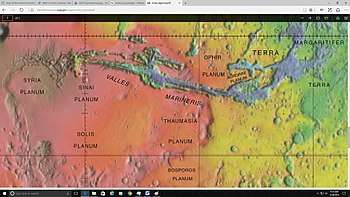 Map of the midwestern part of Mars with Bosporos Planum shown at the bottom | |
| Location | Thaumasia quadrangle (majority) |
|---|---|
| Coordinates | 33°52′S 64°29′E / 33.87°S 64.49°ECoordinates: 33°52′S 64°29′E / 33.87°S 64.49°E |
| Length | 730 |
| Discoverer | Mariner 9 |
Bosporos Planum (sometimes as Bosporus Planum) is a high plateau located in the northeast of the Thaumasia quadrangle in the Southern Hemisphere of Mars, the easternmost portion is in the Argyre quadrangle and a small part with the northernmost area is in the Coprates quadrangle. It is about 730 km long stretching from southwest to northeast. It is located northwest of the large impact basin of Argyre Planitia and is south and south of Thaumasia Planum and the longest canyon Valles Marineris and is next to Coracis Fossae to the west. The feature was first named as Erythraeum Planum,[1] later it was changed into its current name in 1979 by the International Astronomical Union (IAU) Working Group for Planetary System Nomenclature (WGPSN).[2] Its name derives from one of the classical albedo features observed by early astronomers, named after the Bosporus Strait.[2]
It is located east of the upper portion of the midwestern part of the planet outside the volcanic mountain chain with its mean elevation higher the surrounding Argyre Planitia, the areas toward the northeast and Valles Marineris to the north
The plain borders by the crater Babakin to the southwest, Tabor to the southwest, Ogygis Rupes further east and Protva Valles to the northeast.
The plain was first imaged by Mariner 9 in 1971, more detailed images of the plain were later imaged by the Viking Orbiters and the MOC. On April 10, 2006, the first color image was taken by the Mars Reconnaisance Orbiter (MRO)'s HiRISE .
Craters
Craters inside the plain include:
- Aki
- Kontum
- Kumak
- Vik
References
- ↑ "Erythraeum Planum". Gazetteer of Planetary Nomenclature (USGS). International Astronomical Union. Retrieved June 13, 2018.
- 1 2 "Bosporos Planum". Gazetteer of Planetary Nomenclature. USGS Astrogeology Research Program.
External links

- NASA Astronomy Picture of the Day: Mars: The View from HiRISE (10 April 2006)