Boonoo Boonoo, New South Wales

Boonoo Boonoo is a locality in New South Wales, Australia.
Location
It is a locality about 15km west of Boorook and 12 km north of London Bridge within the Tenterfield Shire and is part of Buller County, New South Wales.[1] The nearest settlement is Liston, New South Wales. It lies just south of the Queensland state border.
Geography
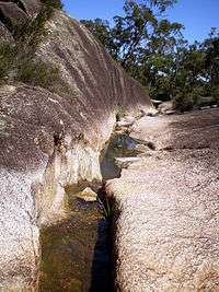
The etymology of Boonoo Boonoo is Aboriginal for "poor country with no animals to provide food" and is pronounced 'bunna bunoo'.[2] The local geography is dominated by prominent granite inselbergs and mountains.
The main geographic features in the locality are Boonoo Boonoo National Park, Boonoo Boonoo River and Falls, Bald Rock National Park and Mount Lindesay Highway.
History
Gold was discovered in the district in 1858,[3] and the economy today is mainly beef cattle breeding and superfine wool production through the breeding of Merino sheep.
References
- ↑ "Boonoo Boonoo". Geographical Names Register (GNR) of NSW. Geographical Names Board of New South Wales. Retrieved 6 March 2016.
- ↑ "Boonoo Boonoo National Park | NSW National Parks". Environment.nsw.gov.au. Retrieved 2013-06-24.
- ↑ Halliday, Ken, Call of the Highlands, Southern Cross Printery, Toowoomba, 1988.
Coordinates: 28°53′05″S 152°06′20″E / 28.88472°S 152.10556°E