Bogusza
| Bogusza | |
|---|---|
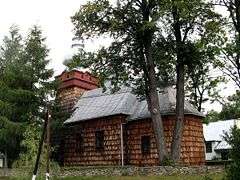 Wooden Orthodox church in Bogusza | |
 Bogusza | |
| Coordinates: 49°34′N 20°53′E / 49.567°N 20.883°E | |
| Country |
|
| Voivodeship | Lesser Poland |
| County | Nowy Sącz County |
| Gmina | Gmina Kamionka Wielka |
| Area | |
| • Total | 12.97 km2 (5.01 sq mi) |
| Population (2006) | |
| • Total | 610 |
| • Density | 47/km2 (120/sq mi) |
| Time zone | UTC+1 (CET) |
| • Summer (DST) | UTC+2 (CEST) |
| Postal code | 33-334 |
| Area code(s) | +48 18 |
| Car plates | KNS |
Bogusza [bɔˈɡuʂa] (Rusyn: Боґуша, Bogusha; Ukrainian: Богуша, Bohusha) is a village in southern Poland. It lies approximately 8 kilometres (5 mi) east of Kamionka Wielka, 15 km (9 mi) south-east of Nowy Sącz, and 88 km (55 mi) south-east of the regional capital Kraków.
Geography
Bogusza is located in a mountain valley in the Lesser Poland Voivodeship, along a stream named the Królówka, in the county of Nowy Sącz.
History
The town was essentially de-populated after World War II in Operation Vistula in 1947.
Monuments
The town is the site of the wooden church of St. Demetrius, built in 1858.
Coordinates: 49°34′N 20°53′E / 49.567°N 20.883°E
This article is issued from
Wikipedia.
The text is licensed under Creative Commons - Attribution - Sharealike.
Additional terms may apply for the media files.