Bisonvalley
| Bisonvalley | |
|---|---|
| village | |
 | |
| Coordinates: 10°0′0″N 77°4′0″E / 10.00000°N 77.06667°ECoordinates: 10°0′0″N 77°4′0″E / 10.00000°N 77.06667°E | |
| Country |
|
| State | Kerala |
| District | Idukki |
| Government | |
| • Type | grama panchayath |
| Area | |
| • Total | 144 km2 (56 sq mi) |
| Population (2001) | |
| • Total | 12,761 |
| • Density | 89/km2 (230/sq mi) |
| Languages | |
| • Official | Malayalam, English |
| Time zone | UTC+5:30 (IST) |
| Vehicle registration | KL-68 |
| Nearest city | Munnar |
Bison valley is a village in Udumbanchola Taluk in the Idukki district of the southwestern Indian state of Kerala. Bison valley is situated at around 914 metres (3000 ft) above mean sea level, in the Western Ghats range of mountains. As of 2001 census of India, Bisonvalley had a population of 12761 with 6449 males and 6312 females.
Etymology
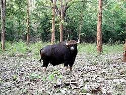
The name Bison valley is believed to tell the history of the place, Where the kings and officers of east India company came for hunting bison during there vacations in Munnar.
Location
Geographic coordinates of Bison valley is 10°00'21.9"N 77°40'36.9"E Bison valley is situated in the valleys of Chokramudi Peak in Udumbanchola taluk in the Idukki district covering an area of nearly 144 square kilometers (56 sq mi).[citation needed]
Road
Bison valley is connected to a rural roads, 24 km form munnar , about 133 km from Cochin, 30 km from Adimali, 147 km from Madurai, Tamil Nadu and 56 km from Neriamangalam.
Railway
The nearest major railway stations are at Ernakulam and Aluva (approximately 140 kilometres by road). The Nearest Functioning Railway station is at Udumalaipettai.
Airport
The nearest airport is Cochin International Airport, which is 110 kilometers away. The Coimbatore and Madurai airports is 165 km from Bison valley.
References