Birriwa, New South Wales
| Birriwa New South Wales | |
|---|---|
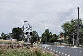 Level crossing at Birriwa | |
|
Birriwa Location in New South Wales | |
| Coordinates | 32°07′13″S 149°28′01″E / 32.12028°S 149.46694°ECoordinates: 32°07′13″S 149°28′01″E / 32.12028°S 149.46694°E |
| Postcode(s) | 2844 |
| Location | |
| LGA(s) | Mid-Western Regional Council |
| State electorate(s) | Orange |
| Federal Division(s) | Parkes |
Birriwa is a locality in central New South Wales, Australia.
Birriwa is located on the Castlereagh Highway in the central west of New South Wales between Gulgong and Dunedoo.
The Gwabegar railway line came to Birriwa and a station was opened there in 1909. There is no longer a passenger service, but a large grain silo remains in operation where the railway line crosses the Castlereagh Highway at a level crossing.
The Chinese bushranger Sam Poo shot and killed policeman John Ward at Birriwa in 1865.
References
| Wikimedia Commons has media related to Birriwa, New South Wales. |
This article is issued from
Wikipedia.
The text is licensed under Creative Commons - Attribution - Sharealike.
Additional terms may apply for the media files.