Binsar Devta
| Bindeshwar Mahadev | |
|---|---|
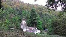 Binsar temple before demolition, with Deodar forest in the background | |
 Location in Uttarakhand | |
| Geography | |
| Coordinates | 30°00′59″N 79°09′44″E / 30.0165°N 79.1621°ECoordinates: 30°00′59″N 79°09′44″E / 30.0165°N 79.1621°E |
| Country | India |
| State | Uttarakhand |
| District | Pauri Garhwal district |
| Location | Pauri Garhwal, Uttarakhand |
| Elevation | 2,500 m (8,202 ft) |
| Architecture | |
| Architecture | Hinduism |
Bindeshwar Mahadev, popularly known as Binsar Mahadev or simply Binsar, is an ancient rock temple situated in Chauthan region of Thalisain Block in Pauri Garhwal district, Uttarakhand. Situated at an altitude of 2490 metres (8169 ft), it stands at the edge of a dense Deodar (Cedrus Deodara) forest. The main deity of this temple is Binsar or Bindeshwar, a form of lord Shiva and a popular deity in the region. The original structure of the temple was ancient and had great archaeological significance but was demolished by some local politicians in order to make a new structure. This happened partly because of locals' inactivity and also because of the fact that ASI had not taken the temple under its protection, even after multiple requests. The central room of the temple was beautifully adorned by the idols of Ganesh, Shiva-Parvati and Mahishasuramardini. A huge fair is organized here on Vaikunth Chaturdashi every year.
 Deodar forest at Bindeshwar Mahadev
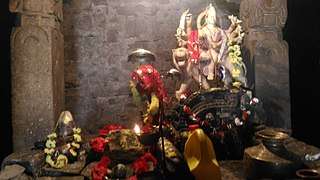 Sanctum Sanctorum of the temple with carved monolithic pillars
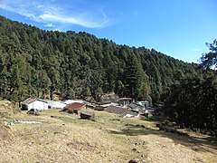 The temple after demolition in October 2017
History
The temple is said to be built in the Katyuri style . It was a contemporary of Jageshwar and Adi-Badri group of temples but no recorded history of the temple exists. Many rock cut idols, shrines, and shiva-lingas lie scattered in the tiny valley. Many historians and researchers have visited the location but no-one could come up with accurate historical data. There have always been speculations but no accurate facts and figures.
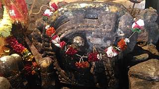 An unknown deity's idol - considered as the main deity at Bindeshwar temple
 Ancient rock temple in Binsar
 Ancient rock cut idols in Binsar
 Temple complex
Folk-lore
As no recorded history is found, many legends and folklores cropped up in later periods. It is believed that the temple was built by Pandavas in one night while on exile. Another legend/folklore says that the temple was built by a king named Bindu but it is not backed by historical facts and figures. Some locals are of the belief that the temple was built by Vishwakarma himself. A strange symbol inscribed outside the temple was said to be his hand-writing. The temple had always been shrouded in mystery. In earlier days the central room of the temple housed a circular, narrow and deep reservoir of very cold water, resembling a well which formed the main shrine. Many idols were kept around it. A snake was said to dwell in the reservoir. In recent times, the well had been covered with flat stones. Until recently, water still seeped out of the rocks suggesting a well/reservoir underneath.
Geography
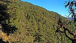
The temple structure lied in a small hanging valley in the vast Dudhatoli region. The altitude of the entire temple complex ranges from 2480 metres (8136 ft) to 2500 metres (8202 ft). The whole complex was on a meadow which lies in a forest clearing. The forest around the temple is one of the densest temperate forests in Uttarakhand with Deodar (Cedrus Deodara) as the dominant tree species. Going further east, Deodar becomes the only tree species. This tiny valley is dotted with cool water springs, at least 6 in number. Some have been channeled into rock formations (known as Mangārā in Garhwali language) whereas some flow naturally (known as dhārā). The surrounding ridges have an average elevation of 2700 metres (8860 ft) with dense mixed broadleaf forests, containing Kharsu and Moru Oaks, Hornbeam, Maple, Rhododendrons, Hazelnut (Corylus Jacquemontii) and dozens other species.
Climate
The region gets temperate climate during summer with pleasant days and cool nights. Monsoon brings lot of rain and the surrounding forests are always covered in mist during monsoon. This season brings a lot of biodiversity to the region. Verdant greenery, along with lots of ferns, mosses, lichens, mushrooms, birds, insects. The rock temples become green after getting covered in moss and lichens during this period. Winter brings lot of snowfall and the temperatures fluctuate a lot during the day. Days are warm and pleasant having bright sunshine with temperatures around 15 °C whereas nights are extremely cold. Sun rises late and sets early during this period causing further cold during the darkness hours. Frost is common during this season and snowfall ranges from 1 ft (30 cm) to as high as 4 ft (120 cm) and more.
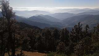 Chauthan valley as seen from Bindeshwar temple
 Approaching pre-historic Dwarpal caves
 Deodar Forest seen while approaching Binsar Valley
How to reach
There are many ways to reach the temple; however, two routes are most commonly used. First route is Thalisain-Peethsain-Binsar. There is a good motorable road from Thalisain (NH 121) to Peethsain (2260 metres). From Peethsain there is a long but gentle trek of 11 kilometres. Second route is Jagatpuri-Chounda-Binsar, which is a steep, uphill trek of around 6 kilometres. Jagatpuri is a roadside market, reachable from Baijro-Uffrainkhal in Garhwal and from Deghat in Kumaon (18 kilometres).
Nearby Places
Brahmadhungi

Brahmadhungi is a huge cliff/rock perched on top of a high hill. It is half an hour trek away from the temple of Bindeshwar Mahadev. A small shrine is built on top of that rock. It has views of snow-clad Trisul massif and surrounding hills and valleys.
Peethsain
Peethsain is located on a gently rolling hill at an altitude of 2260 metres in Raath cultural region. Uttarakhand Government is planning to develop it as a Hill Station and an eco-tourism zone. It is well known as birthplace of famous freedom fighter Veer Chandra Singh Garhwali. The temperate climate and smooth sandy-loamy soil is perfect for alpine fruits and root vegetabes such as potatoes. This Sandy stone-less soil is typical to the entire Thalisain region.
Daida
Daida is a village just below Binsar temple. It is an ideal base for jungle-trekking in the Dudhatoli ranges. With less number of inhabitants and splendid houses featuring traditional Garhwali architecture, there are decent accommodation facilities here. A Government Forest Rest House and a Panchayat Rest House give accommodation to visitors. Guides can also be hired here for Dudhatoli jungle treks.
Dudhatoli

Known as Pamirs of Uttarakhand (average elevation of 2900 to 3000 metres), with gently rolling mountains and expansive meadows, Dudhatoli lies at the geographical centre of Uttarakhand state. It is home to the densest as well as largest temperate broadleaf and coniferous forests in the state. Musa ka kotha, at 3100 metres, is the highest point in the lower himalayas of Uttarakhand. This region is a wonderland of untouched virgin beauty and has a huge potential to be developed as a tourist attraction. It is also the source of many non-glacial perennial rivers; Eastern Nayar, Western Nayar, Ramganga (West), Atta-gad and Bino being the major ones; not to mention the innumerable water springs and streams that drain into these rivers.
Image gallery
 The temple after demolition in October 2017
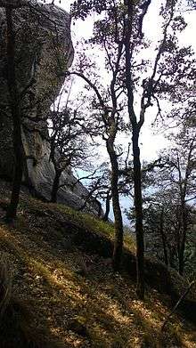 Brahmadhungi
 A small shrine made with rocks seen on Peethsain-Binsar route
 A fresh water spring in Binsar
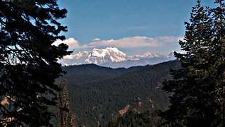 View of Chaukhamba from the ridge
 The winter-line as seen from Binsar
 More caves near Dwarpal