Bhatauli (Kanpur Dehat)
| Bhatauli (Kanpur Dehat) | |
|---|---|
| Village | |
 Bhatauli (Kanpur Dehat) Location in Uttar Pradesh, India  Bhatauli (Kanpur Dehat) Bhatauli (Kanpur Dehat) (India) | |
| Coordinates: 26°29′N 79°54′E / 26.48°N 79.9°ECoordinates: 26°29′N 79°54′E / 26.48°N 79.9°E | |
| Country |
|
| State | Uttar Pradesh |
| District | Kanpur Dehat |
| Elevation | 127 m (417 ft) |
| Population (2001) | |
| • Total | 8,000 |
| Languages | |
| • Official | Hindi |
| Time zone | UTC+5:30 (IST) |
| PIN | 209303 |
| Telephone code | 915111 |
| Website |
www |
Bhatauli[1] is an Indian village of Kanpur Dehat district in Uttar Pradesh.It is an adjacent to city Rura, Kanpur Dehat District, Utter Pradesh, India. Bhatauli is the commercial center of grain and vegetables. It is well known place for potatoes cold storage.Many primary schools in govt.sector while many others in private (recognized).Saraswati Gyan Mandir Inter College is also here. Jog Mai (Durga Mandir) is a center of faith. The Shiv Bajrang Dham Kishunpur is 200 metres (660 ft) away.
Transport
It is connected with city Rura Railway Station (NCR) at distance 400 m. Rura is a main Railway Station of Kanpur Dehat District. It is connected with fast &super fast trains to Kanpur, Lucknow, Hawrah Delhi, Dehradoon, Meerut etc. It is linked with Golden Quadrilateral National High Way of India at Mugisapur & Akbarpur at a distances 18 km & 14 km. Akbarpur-Derapur Road (via Rura) passes through the middle of the town. Following main trains are available: Main Express Trains
- Gomti Express (super fast).
- Agra-Lucknow Intercity Express.
- Toofan Express
- Anand Bihar-Kolkata Express.
- Mahananda Express.
- Rourkela/Jammu Tawi Muri Express
- Unchahar Express .
- Sangam Express (up) .
Schools
- Saraswati Gyan Mandir Inter College
- Upper Primary School
Geography
Bhatauli is located at 26°29′N 79°54′E / 26.48°N 79.9°E.[2] It has an average elevation of 127 metres (416 feet).
Station details
- Station name: Rura
- Station code: rura
- Town :Bhatauli-Rura
Demographics
As of 2001 India Area map [3]
Gallery
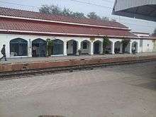 Rura Railway Station
 Over bridge
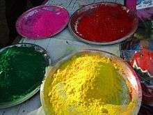 Holi -Holi
.jpg) Banyan Tree (Shiv Bajrang Dham Kishunpur
Banyan Tree (Shiv Bajrang Dham Kishunpur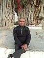 Baniyan Tree
.jpg) Jog Mai Mandir
Jog Mai Mandir.jpg) Starling (मैना )
Starling (मैना )
.
References
- ↑ https://villageinfo.in/uttar-pradesh/kanpur-dehat/akbarpur/bhatauli.html
- ↑ "Maps, Weather, Videos, and Airports for Bhatauli- Rura, India". Falling Rain Genomics, Inc. Retrieved 2015-01-10.
- ↑ https://www.google.co.in/maps/place/Rura,+Uttar+Pradesh+209303/@26.48899,79.8848317,14z/data=!3m1!4b1!4m5!3m4!1s0x399dc64aa45c2957:0x586ed38b0c42ba88!8m2!3d26.4820748!4d79.900592?hl=en