Beit Hillel
| Beit Hillel בֵּית הִלֵּל | |
|---|---|
 | |
 Beit Hillel | |
| Coordinates: 33°12′27″N 35°36′20.51″E / 33.20750°N 35.6056972°ECoordinates: 33°12′27″N 35°36′20.51″E / 33.20750°N 35.6056972°E | |
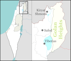
| District | Northern |
| Council | Mevo'ot HaHermon |
| Affiliation | Moshavim Movement |
| Founded | 1940 |
| Population (2017)[1] | 799 |
| Website | www.beit-hillel.org.il |
Beit Hillel (Hebrew: בֵּית הִלֵּל) is a moshav in northern Israel. Located on the west bank of the Hasbani River, about 5 kilometres from Kiryat Shmona, its 3,500 dunams fall under the jurisdiction of Mevo'ot HaHermon Regional Council. In 2017 it had a population of 799.[1]
History
The moshav was founded in 1940 as one of the Ussishkin fortresses by a mixed group of immigrants from Europe and native Sabras, for workers in the tower and stockade settlements in the Upper Galilee. It was named after Hillel Yaffe, a doctor who immigrated to Mandatory Palestine during the Second Aliyah. During the 1948 Arab–Israeli War Beit Hilel was temporarily abandoned due to the battles in the area; at that time, the village had a population of 98 and settled on an area of 1,085 dunams (1,085 square kilometers). Settlement was resumed in 1950, with the village taking land that had belonged to the depopulated Palestinian village of Al-Zuq al-Tahtani;[2] the new inhabitants were mainly Jews from Europe who survived the Holocaust.[3]
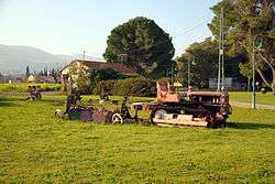
Today the inhabitants of the moshav make their livelihood from agriculture, breeding cows and tourism.
Geography
It lies at an altitude of 85 meters in the northernmost tip of Upper Galilee in the Hula valley at the top of the Jordan River.
The village is located about 3 kilometers east of the town of Kiryat Shmona, about 147 kilometers northeast of Tel Aviv's center and about 72 kilometers northeast of Haifa.
Beit Hillel is connected to the transport network via the local road number 9888, which leads north of the village to the 99 motorway leading to the Golan Heights.
In Beit Hillel, pre-school care facilities are available. The primary school is in nearby Kfar Gil'adi. High School in Kfar Blum. Beit Hillel has a synagogue, a health center and a grocery store.
Demography
The population of Beit Hillel is secular. According to the 2014 data, the vast majority of Beit Hillel Jews (including the "other" statistical category, which includes non-Jewish inhabitants of Jewish origin but without formal jurisdiction over the Jewish religion), formed the vast majority of the population.
Notable residents
References
- 1 2 "List of localities, in Alphabetical order" (PDF). Israel Central Bureau of Statistics. Retrieved August 26, 2018.
- ↑ Khalidi, Walid (1992). All That Remains: The Palestinian Villages Occupied and Depopulated by Israel in 1948. Washington D.C.: Institute for Palestine Studies. p. 510. ISBN 0-88728-224-5.
- ↑ About us Beit Hillel