Bernadeinkopf
| Bernadeinkopf | |
|---|---|
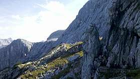 Northern wall of the Alpspitze with via ferrata Nordwandsteig (right), leading to the Bernadeinkopf (left) | |
| Highest point | |
| Elevation | 2,143 m (7,031 ft) |
| Coordinates | 47°25′48″N 11°03′32″E / 47.43°N 11.058889°ECoordinates: 47°25′48″N 11°03′32″E / 47.43°N 11.058889°E |
| Geography | |
| Parent range | Alps, Wetterstein |
| Climbing | |
| Easiest route | alpine hike or via ferrata |
Bernadeinkopf (elevation 2,143 m (7,031 ft)) is a summit of the Wetterstein range in the German state of Bavaria.
Alpinism
The Bernadeinkopf lies below the eastern ridge of the Alpspitze, which continues in its northern steep walls. The southern side is in contrast less steep and leads to the lake Stuibensee.
Several via ferrata access the summit, easy and moderate Nordwandsteig and Schöngänge, or Mauerläufersteig of difficulty D-E. All of them can be easily reached after short hikes from the top station of the cable car at Osterfelderkopf. Access to the summit is also possible in winter through the southern side as ski tour.
The closest shelter is the restaurant at the Osterfelderkopf.
Gallery
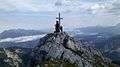 Cross at summit
| Wikimedia Commons has media related to Bernadeinkopf. |
This article is issued from
Wikipedia.
The text is licensed under Creative Commons - Attribution - Sharealike.
Additional terms may apply for the media files.