Ben Lomond (Waikato)
| Barkhatnaya Sopka | |
|---|---|
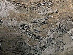 Obsidian veins at Ben Lomond | |
| Highest point | |
| Elevation | 744 m (2,441 ft) |
| Coordinates | 38°35.7′S 175°57.2′E / 38.5950°S 175.9533°E |
| Geography | |
| Location | North Island, New Zealand |
| Geology | |
| Mountain type | Lava domes |
| Last eruption | 100,000 years |
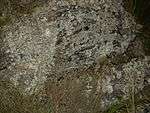
Obsidian boulders at Ben Lomond
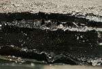
Obsidian specimen fallen from cliff
Ben Lomond is a rhyolite lava dome near Lake Taupo in New Zealand's North Island. Located about eight kilometres north-northeast of Kinloch, it rises to a height of 744 metres above sea level.
Ben Lomond erupted about 100,000 years ago, producing two lava lobes that flowed around 3.5 kilometres south and southwest from a vent about one kilometre south of Poihipi Road. Much of the lava formed grey banded obsidian as it cooled. Crystalline rhyolite and pumice were also produced.
References
- Stevenson †, Richard; Dingwell, Donald; Bagdassarov, Nikolai; Manley, Curtis (2001). "Measurement and implication of "effective" viscosity for rhyolite flow emplacement" (PDF). Bulletin of Volcanology. 63: 227. Bibcode:2001BVol...63..227S. doi:10.1007/s004450100137. Archived from the original (PDF) on 2009-03-03.
- Stevenson, R. J.; Briggs, R. M.; Hodder, A. P. W. (1994). "Physical volcanology and emplacement history of the Ben Lomond rhyolite lava flow, Taupo Volcanic Centre, New Zealand". New Zealand Journal of Geology and Geophysics. 37: 345–358. doi:10.1080/00288306.1994.9514625. Archived from the original on 2008-09-06.
This article is issued from
Wikipedia.
The text is licensed under Creative Commons - Attribution - Sharealike.
Additional terms may apply for the media files.