Belair, South Australia
| Belair Adelaide, South Australia | |
|---|---|
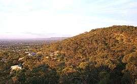 Part of the view north from Windy Point | |
 Belair | |
| Coordinates | 34°59′53″S 138°37′21″E / 34.998118°S 138.622540°ECoordinates: 34°59′53″S 138°37′21″E / 34.998118°S 138.622540°E |
| Population |
|
| Postcode(s) | 5052 |
| LGA(s) | City of Mitcham |
| State electorate(s) | Waite |
| Federal Division(s) | Boothby |
Belair is a suburb in the south eastern foothills of Adelaide, South Australia at the base of the Mount Lofty Ranges.
Geography
Belair was established during the settlement of Adelaide as a source of timber. Parts of Belair have views of the city of Adelaide, the Adelaide Plains and the coast. Belair National Park is one of the major attractions of the suburb, and Windy Point (formerly known as Observation Point) provides a 230 degree panorama making it one of the best lookouts over the city, the plains and the coast.
Recreational facilities
Belair National Park is a very popular location for feeding ducks, cycling, walking or horseriding through the bush, enjoying the native flora and fauna, having barbecues and playing social games of tennis, football, soccer and 'backyard' cricket. Belair Country Club hosts an 18-hole public golf course adjacent to the National Park.
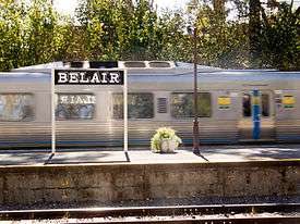
Belair is also a very popular area for mountain bikers. There are bike trails not just in the National Park but throughout Belair, and steep tracks down the hills face to railway stations on the Belair line, which terminates adjacent to the National Park.
History
The origin of the name 'Belair' appears uncertain. Gustav Ludewigs, who subdivided the area, may have named the suburb after Bel Air, Martinique, being his wife Maria's birthplace.[3] Another theory is that it was named in 1849 after Eugene Bellairs, a Government surveyor who lived in the area.[4]
A Belair Post Office opened on 3 April 1859; it was relocated in 1881 to near its present position and the original office renamed Blackwood.[5]
Accessibility
Belair is approximately a fifteen-minute drive from the Adelaide city centre. Belair railway station is the terminus of the suburban Belair railway line.
Education
Belair schools consist of a co-located junior school and an upper primary school situated on Main Road, Belair. The schools have Eco-school status,[6] and follow the International Baccalaureate syllabus.[7] In 1999 the schools twinned with Momoyama Elementary School in Kyoto, Japan.[7] Every two years, during May, a group of students and staff travel to Kyoto. In the alternate year, Momoyama students and staff visit Belair during August. These visits have become an integral part of the schools' Japanese language and cultural programme.
St John's Grammar School also has a junior campus adjacent to the railway station and senior campus located towards the west of the suburb. Actors Ben Nicholas and Sarah Snook are some of its more famous graduates.
Downhilling
There are numerous mountain biking tracks throughout Belair, and the City of Mitcham is expanded and formalised these tracks in the early 21st century. In November 2010 a two-metre-wide bitumen track opened between Caroline Avenue, Belair, and Beagle Terrace, Lynton, providing a trail for cyclists as an alternative to the dangerous curves of Belair Road. There are other tracks leading down to Lynton Train Station and Mitcham.
Climate
| Climate data for Belair (Kalyra) (305m ASL) | |||||||||||||
|---|---|---|---|---|---|---|---|---|---|---|---|---|---|
| Month | Jan | Feb | Mar | Apr | May | Jun | Jul | Aug | Sep | Oct | Nov | Dec | Year |
| Record high °C (°F) | 43.1 (109.6) |
40.9 (105.6) |
39.4 (102.9) |
34.2 (93.6) |
27.5 (81.5) |
21.5 (70.7) |
23.2 (73.8) |
25.2 (77.4) |
31.0 (87.8) |
33.3 (91.9) |
41.3 (106.3) |
39.0 (102.2) |
43.1 (109.6) |
| Average high °C (°F) | 26.7 (80.1) |
27.0 (80.6) |
24.2 (75.6) |
20.3 (68.5) |
16.5 (61.7) |
13.4 (56.1) |
12.5 (54.5) |
13.8 (56.8) |
16.1 (61) |
19.5 (67.1) |
22.6 (72.7) |
24.8 (76.6) |
19.8 (67.6) |
| Daily mean °C (°F) | 20.7 (69.3) |
21.2 (70.2) |
19.2 (66.6) |
16.2 (61.2) |
13.3 (55.9) |
10.6 (51.1) |
9.8 (49.6) |
10.6 (51.1) |
12.3 (54.1) |
14.8 (58.6) |
17.2 (63) |
19.0 (66.2) |
15.4 (59.7) |
| Average low °C (°F) | 14.7 (58.5) |
15.3 (59.5) |
14.1 (57.4) |
12.0 (53.6) |
10.1 (50.2) |
7.8 (46) |
7.0 (44.6) |
7.4 (45.3) |
8.4 (47.1) |
10.0 (50) |
11.8 (53.2) |
13.2 (55.8) |
11.0 (51.8) |
| Record low °C (°F) | 6.7 (44.1) |
8.4 (47.1) |
7.6 (45.7) |
4.2 (39.6) |
3.3 (37.9) |
2.6 (36.7) |
0.5 (32.9) |
2.8 (37) |
3.0 (37.4) |
2.9 (37.2) |
4.6 (40.3) |
6.0 (42.8) |
0.5 (32.9) |
| Average rainfall mm (inches) | 24.4 (0.961) |
24.6 (0.969) |
30.8 (1.213) |
58.2 (2.291) |
93.2 (3.669) |
100.9 (3.972) |
97.5 (3.839) |
86.8 (3.417) |
73.5 (2.894) |
58.7 (2.311) |
40.1 (1.579) |
34.0 (1.339) |
724.0 (28.504) |
| Average rainy days | 4.0 | 3.8 | 4.7 | 9.0 | 13.0 | 14.0 | 16.4 | 15.3 | 12.7 | 10.5 | 7.3 | 5.6 | 116.3 |
| Average relative humidity (%) (at 3pm) | 46 | 46 | 47 | 60 | 69 | 76 | 77 | 71 | 63 | 58 | 54 | 51 | 60 |
| Source: [8] | |||||||||||||
References
- ↑ Australian Bureau of Statistics (31 October 2012). "Belair (State Suburb)". 2011 Census QuickStats. Retrieved 14 February 2015.

- ↑ Australian Bureau of Statistics (25 October 2007). "Belair (State Suburb)". 2006 Census QuickStats. Retrieved 2 July 2008.
- ↑ "The Manning Index of South Australian History - Belair". State Library of South Australia. Archived from the original on 29 July 2008. Retrieved 9 July 2008.
- ↑ "Belair". City of Mitcham. Retrieved 28 April 2010.
- ↑ Premier Postal History. "Post Office List". Premier Postal Auctions. Retrieved 26 May 2011.
- ↑ "Belair Eco School" Archived 28 July 2008 at the Wayback Machine., Department of Environment and Heritage, accessed 8 July 2008
- 1 2 "Belair Primary School", Department of Education and Children's Services, accessed 8 July 2008
- ↑ "Climate Data Online". Retrieved January 14, 2018.
External links
| Wikimedia Commons has media related to Belair, South Australia. |
- Belair Schools
- View of the city from Windy Point (Copyright Mitcham Council)