Beinn Dearg Mòr
| Beinn Dearg Mòr | |
|---|---|
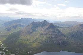 Beinn Dearg Mor from Sail Liath, August 2009 | |
| Highest point | |
| Elevation | 906.3 m (2,973 ft) |
| Prominence | 568 m (1,864 ft) |
| Listing | Corbett, Marilyn |
| Coordinates | 57°45′56″N 5°18′36″W / 57.7655°N 5.3099°WCoordinates: 57°45′56″N 5°18′36″W / 57.7655°N 5.3099°W |
| Naming | |
| Translation | Big red mountain (Gaelic) |
| Pronunciation | Scottish Gaelic: [ˈpeiɲ ˈtʲɛɾɛk moːɾ] |
| Geography | |
| Location | Dundonnell and Fisherfield Forest, Scotland |
| OS grid | NH03217993 |
| Topo map | OS Landranger 19 |
Beinn Dearg Mòr is a peak in the Dundonnell and Fisherfield Forest of the Northwest Highlands in Scotland. It rises to an elevation of 906 metres (2,972 ft) above sea level.
Beinn Dearg Mòr was marked on Ordnance Survey maps with an elevation of 910m. The Munro Society used GPS devices for a height survey of the mountain in 2011, along with the adjacent Ruadh Stac Mòr and Beinn a' Chlaidheimh. Beinn Dearg Mòr was measured as a summit height of 906.28m +/-0.08m, so retains its classification as a Corbett.[1]
References
- ↑ "The Fisherfields Surveys of Beinn a' Chlaidheimh, Beinn Dearg Mor and Ruadh Stac Mor (4th, 6th & 8th July 2011)". The Munro Society. Retrieved 3 November 2014.
| Wikimedia Commons has media related to Beinn Dearg Mòr. |
This article is issued from
Wikipedia.
The text is licensed under Creative Commons - Attribution - Sharealike.
Additional terms may apply for the media files.