Behshahr County
| Behshahr County شهرستان بهشهر Ashraf (اشرف) | |
|---|---|
| County | |
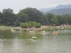 AbbasAbad Garden | |
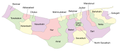 Counties of Mazandaran Province | |
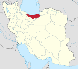 Location of Mazandaran Province in Iran | |
| Coordinates: 36°41′N 53°44′E / 36.683°N 53.733°ECoordinates: 36°41′N 53°44′E / 36.683°N 53.733°E | |
| Country |
|
| Province | Mazandaran |
| Capital | Behshahr |
| Bakhsh (Districts) | Central District, Yaneh Sar District |
| Area[1] | |
| • Total | 1,416.27 km2 (546.82 sq mi) |
| Population (2006) | |
| • Total | 154,957 |
| • Density | 110/km2 (280/sq mi) |
| Time zone | UTC+3:30 (IRST) |
| • Summer (DST) | UTC+4:30 (IRDT) |
| Behshahr County can be found at GEOnet Names Server, at this link, by opening the Advanced Search box, entering "9207234" in the "Unique Feature Id" form, and clicking on "Search Database". | |
Behshahr County (Persian: شهرستان بهشهر, Šahrestân-e Behšahr; Mazanderani: اَشرِفِ شهرستون, Ašref-e-Šahrestun) is a county on the Caspian Sea, in Mazandaran Province of northern Iran.
Geography
The capital of the county is Behshahr. The most important towns of the county are Behshahr and Rostamkola.
At the 2006 census, the county's population was 154,957, in 40,432 families.[2]
The county is subdivided into two districts: the Central District and Yaneh Sar District.
The county has three cities: Behshahr, Rostamkola, and Khalil Shahr.
References
- ↑ Mozaffa F.; Aghae Y.; Taghvaei M.; Shaykh Baygloo R. (Winter 2011). "Analysis of Intraregional Disparities of Development in Mazandaran Ostan" (PDF). Geography and Environmental Planning. 40 (4): 13–28. Retrieved 23 August 2013. Check date values in:
|year= / |date= mismatch(help) - ↑ "Census of the Islamic Republic of Iran, 1385 (2006)". Islamic Republic of Iran. Archived from the original (Excel) on 2011-11-11.
- اطلس گیتاشناسی استانهای ایران [Atlas Gitashenasi Ostanhai Iran] (Gitashenasi Province Atlas of Iran)
External links
| Wikimedia Commons has media related to Behshahr county. |
| Capital | |
|---|---|
| Counties and cities | |
| Sights | 
|
| populated places | |
This article is issued from
Wikipedia.
The text is licensed under Creative Commons - Attribution - Sharealike.
Additional terms may apply for the media files.