Bauges
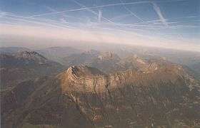
View from the southern part of the Bauges -

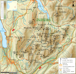
Map of the Bauges mountains
The Bauges Mountains (Massif des Bauges) is a mountain range in eastern France, stretching from the city of Annecy to the city of Chambéry, which is part of the French Prealps.
Major peaks
The Bauges have 14 summits above 2,000 metres (6,562 ft):
- Arcalod, 2,217 metres (7,274 ft), highest point in the range
- Sambuy, 2,198 metres (7,211 ft)
- Pécloz, 2,197 metres (7,208 ft)
- Trélod, 2,181 metres (7,156 ft)
- Pointe de Chaurionde, 2,173 metres (7,129 ft)
- Mont d’Armenaz, 2,158 metres (7,080 ft)
- Pointe des Arces, 2,076 metres (6,811 ft)
- Mont de la Coche, 2,070 metres (6,791 ft)
- Dent de Cons, 2,064 metres (6,772 ft)
- Pointe des Arlicots, 2,060 metres (6,759 ft)
- Mont Colombier, 2,043 metres (6,703 ft)
- Dent d’Arclusaz, 2,040 metres (6,693 ft)
- Grand Parra, 2,012 metres (6,601 ft)
Other noteworthy summits include:
- Semnoz, 1,699 metres (5,574 ft), above Annecy
- Nivolet, 1,547 metres (5,075 ft), above Chambéry
- Mont Revard, 1,562 metres (5,125 ft), above Aix-les-Bains
References
- Fr.Wikipédia: Massif des Bauges (French)
This article is issued from
Wikipedia.
The text is licensed under Creative Commons - Attribution - Sharealike.
Additional terms may apply for the media files.