Basòdino
| Basòdino | |
|---|---|
 | |
| Highest point | |
| Elevation | 3,273 m (10,738 ft) |
| Prominence | 960 m (3,150 ft) [1] |
| Isolation | 10.9 km (6.8 mi) [2] |
| Parent peak | Dammastock |
| Listing | Alpine mountains above 3000 m |
| Coordinates | 46°24′41.8″N 8°28′6.5″E / 46.411611°N 8.468472°ECoordinates: 46°24′41.8″N 8°28′6.5″E / 46.411611°N 8.468472°E |
| Geography | |
 Basòdino Location in the Alps | |
| Location |
Ticino, Switzerland Piedmont, Italy |
| Parent range | Lepontine Alps |
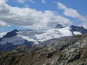
The Basòdino is a mountain in the Lepontine Alps on the border between Italy and Switzerland. It is the second highest peak in the canton of Ticino, after the Rheinwaldhorn.
On its summit is located a geodetic point of IGM named 05A901 Monte Basodino.[3]
SOIUSA classification
According to SOIUSA (International Standardized Mountain Subdivision of the Alps) the mountain is classified in the following way:[4]
- main part = Western Alps
- major sector = North-Western Alps
- section = Lepontine Alps
- subsection = South-western Lepontine Alps
- supergroup = Catena Basodino-Cristallina-Biela
- group = Gruppo del Basodino
- subgroup = Gruppo del Basodino sensu stricto,
- code = I/B-10.II-A.1.b
See also
References
- ↑ Retrieved from the Swisstopo topographic maps. The key col is the San Giacomo Pass (2,313).
- ↑ Retrieved from Google Earth. The nearest point of higher elevation is east of the Corno Rosso (Blinnenhorn massif).
- ↑ "Scheda informativa del punto geodetico". Retrieved 2012-02-15.
- ↑ Marazzi, Sergio (2005). Atlante Orografico delle Alpi. SOIUSA (in Italian). Priuli & Verlucca. ISBN 978-88-8068-273-8.
| Wikimedia Commons has media related to Basodino. |
This article is issued from
Wikipedia.
The text is licensed under Creative Commons - Attribution - Sharealike.
Additional terms may apply for the media files.