Basiani
| Basiani | |
|---|---|
| Region of Anatolia | |
 districts of Tao-Klarjeti kingdom, in X century. | |
| Location | Northeastern Anatolia |
Basiani (Georgian: ბასიანი), also known as Phasiane, was a region in historical southwestern Georgia.
Origin
The name is derived from ancient Colchian tribes called Phasians (Phazians). The name of this tribe seems to have survived in latter-day regional toponyms – Georgian Basiani, Greek Phasiane, Armenian Basean, and Turkish Pasin.
History
In the 8th and 7th centuries B.C. the province was part of Urartu, then it was acquired by the Armenian Kingdom in the 2nd century B.C. In 384, it was a battlefield between Rome and Sasanian Empire. In 7th century, the province was conquered by an Arab Caliphate.
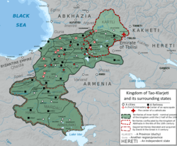
In 10th century Basiani was liberated by the Georgian princedoms of Tao-Klarjeti during the struggle against Arab occupation. In the 10th century, the borders between the Byzantine Empire and Tao-Klarjeti went along the Aras river, thus Basiani was considered as personal domain of the Georgian Bagratids. In 1001, after the death of David III Kuropalates, Tao and Basiani were inherited by Byzantine Emperor Basil II, who organized it into the theme of Iberia with the capital at Theodosiopolis, forcing the successor Georgian Bagratid ruler Bagrat III to recognize the new rearrangement. Bagrat’s son, George I, however, inherited a longstanding claim to David’s succession. While Basil II was preoccupied with his Bulgarian campaigns, George gained momentum to invade Tao and Basiani in 1014, which caused unsuccessful Byzantine-Georgian wars. Despite the territorial losses to Basil II, many of the territories ceded to the empire were conquered by the Seljuk Turks in the 1070s-1080s, but were then retaken by the Georgian King David IV. In the 13th century, at Battle of Basian, Georgians defeated the army of the Rum Sultanate. The province was part of the Kingdom of Georgia as an ordinary duchy till 1545, when Basiani was finally conquered by the Ottoman Empire. In the 17th century, it became a sanjak of Erzurum Vilayet.
See also
Further reading
- D. Muskhelishvili, Georgian Soviet Encyclopedia, Tbilisi, 1977
