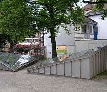
Basel-Münsterhügel
Coordinates: 47°33′21″N 7°35′35″E / 47.5557°N 7.5930°E
The Basel oppidum, known as Basel-Münsterhügel, is an Iron Age fort (oppidum) constructed by the Celtic Rauraci in the second half of the 1st century BC (late La Tène), after the battle of Bibracte (58 BC). The fort was situated on what is now the Münsterhügel in the Swiss city of Basel. The site was excavated by Furger-Gunti in the 1970s.
There is an older undefended La Tène site at Basel Gasfabrik, not far from the oppidum, which was abandoned after the fort was completed.
See also
References
- René Teuteberg, Basler Geschichte Christoph Merian Verlag, 2nd ed. Basel 1988. ISBN 3-85616-034-5, p. 52.
- Andres Furger-Gunti, Oppidum Basel-Münsterhügel. Grabungen 1971-72 an der Rittergasse 5, Jahrbuch SGU, 1974/75, pp. 77–111.
- Andres Furger-Gunti, Das spätkeltische Oppidum von Basel-Münsterhügel: Der Murus Gallicus, Archäologisches Korrespondenzblatt 2, 1972, pp. 165–168.
- Andres Furger-Gunti, Das keltische Basel (1981).
External links
This article is issued from
Wikipedia.
The text is licensed under Creative Commons - Attribution - Sharealike.
Additional terms may apply for the media files.
